PEEL WATERSHED PLANNING REGION:
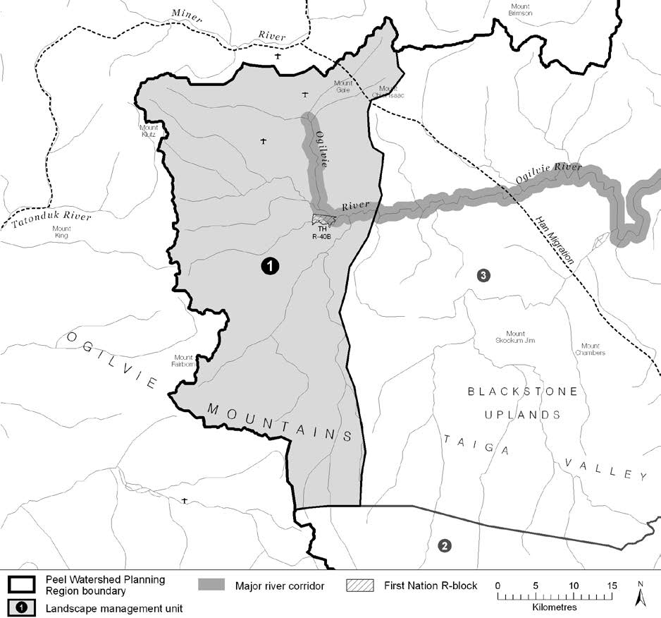
LMU 1: Ogilvie River Headwaters
[dvmd_table_maker tbl_column_header_count=”0″ tbl_responsive_breakpoint=”max_width_767″ tbl_responsive_break_by=”row” _builder_version=”4.21.0″ _module_preset=”default” global_colors_info=”{}” _i=”0″ _address=”0.1.0.0″ theme_builder_area=”post_content” /]


Objectives
- Wilderness character is maintained.
- Culturally important sites intact.
- Winter habitat of the Porcupine caribou herd without recent disturbances.
- Water quality and flow from the Ogilvie headwaters not affected by human activities.
- Community cultural activities practised without significant disturbance.
Rationale for Designation
- Culturally important travel route with historic and prehistoric settlements.
- TH consider this area important for long-term sustenance.
- Includes the headwaters of the Ogilvie watershed, and is considered important for water quality.
- Extensive concentrated and general use areas for the Porcupine herd.
- Includes a portion of the Blackstone Uplands, which were considered a candidate for protection by the Peel River Watershed Advisory Committee.
- Generally low non-renewable resource development potential, because of lower mineral and oil and
gas potentials, and distance from an existing road.
[dvmd_table_maker tbl_title_mode=”on” tbl_title_text=”Cumulative Effects Thresholds” tbl_row_header_count=”0″ tbl_responsive_break_by=”row” _builder_version=”4.27.0″ _module_preset=”default” global_colors_info=”{}” _i=”0″ _address=”0.4.0.0″ theme_builder_area=”post_content” /][dvmd_table_maker tbl_row_header_count=”0″ tbl_responsive_break_by=”row” _builder_version=”4.27.0″ _module_preset=”default” global_colors_info=”{}” _i=”1″ _address=”0.4.0.1″ theme_builder_area=”post_content” /][dvmd_table_maker tbl_column_header_count=”0″ tbl_row_header_count=”0″ _builder_version=”4.27.0″ _module_preset=”default” global_colors_info=”{}” _i=”2″ _address=”0.4.0.2″ theme_builder_area=”post_content” /]
Cumulative Effects Indicators
Surface Disturbance
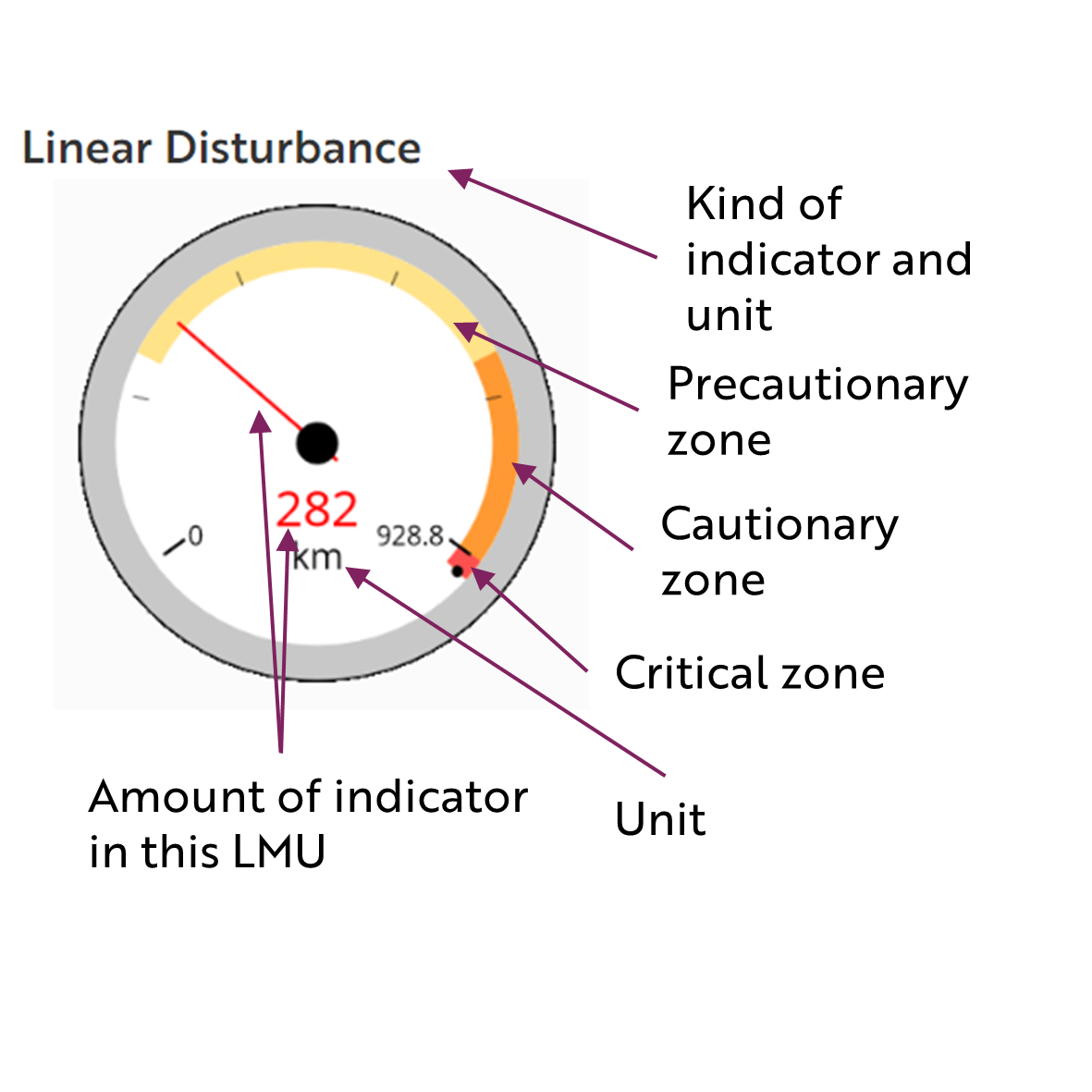
Linear Disturbance
[dvmd_table_maker tbl_column_header_count=”0″ tbl_row_header_count=”0″ _builder_version=”4.25.0″ _module_preset=”default” global_colors_info=”{}” _i=”1″ _address=”1.2.0.1″ theme_builder_area=”post_content” /]
[dvmd_table_maker tbl_title_mode=”on” tbl_title_text=”Biophysical Setting” tbl_column_header_count=”0″ tbl_column_max_width=”1.6fr” tbl_column_min_width=”28px” tbl_responsive_break_by=”row” _builder_version=”4.21.0″ _module_preset=”default” global_colors_info=”{}” _i=”0″ _address=”2.0.0.0″ theme_builder_area=”post_content” /]

[dvmd_table_maker tbl_title_mode=”on” tbl_title_text=”Ecological Resources” tbl_column_header_count=”0″ tbl_responsive_break_by=”row” _builder_version=”4.21.0″ _module_preset=”default” global_colors_info=”{}” _i=”0″ _address=”2.1.0.0″ theme_builder_area=”post_content” /]
[dvmd_table_maker tbl_title_mode=”on” tbl_title_text=”Heritage, Social and Cultural Resources” tbl_column_header_count=”0″ tbl_responsive_break_by=”row” _builder_version=”4.21.0″ _module_preset=”default” global_colors_info=”{}” _i=”0″ _address=”2.2.0.0″ theme_builder_area=”post_content” /]
[dvmd_table_maker tbl_title_mode=”on” tbl_title_text=”Economic Development” tbl_column_header_count=”0″ tbl_responsive_break_by=”row” _builder_version=”4.21.0″ _module_preset=”default” global_colors_info=”{}” _i=”0″ _address=”2.3.0.0″ theme_builder_area=”post_content” /]
Special Management Considerations
None
These gauges show how much of each disturbance indicator there is in the LMU with the needle and the large number near the middle. The colours indicate disturbance level zones or “thresholds”. If the needle is in the white zone, no management threshold has been reached.
Learn about our recommended Cumulative Effects Framework on here.

[dvmd_table_maker _builder_version=”4.24.2″ _module_preset=”default” global_colors_info=”{}” _i=”0″ _address=”3.1.0.0″ theme_builder_area=”post_content” /]
