|
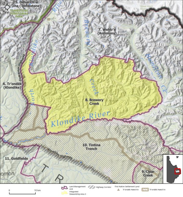
Land Use Designation: |
Integrated Stewardship Area 3 |
||
|
Land Status: |
Non-Settlement Land and Tr’ondëk Hwëch’in Settlement Land TH R-63A, TH S-159B1, TH S-203B, TH S-204B1, TH S-80B1 |
||
|
Area: |
948 km2 |
Planning Region % |
2.4% |
|
|
||||
|
|
||||
|
Walking on the Land Together (Intent Statement) |
||||
|
The vision for this area is sustainable development by means of cumulative effects management, access management, and the preservation of key values. This area contains a past-producing heap-leach mine and associated infrastructure which has the potential to re-open. Forestry is an important value in this area. It is also the location of considerable habitat for key wildlife species and socio-cultural use. It is important that this area remain open for current and future mineral interests without undermining its important environmental and cultural attributes. |
||||
|
Tr’ëhudè (Our Way of Life) & Stewardship |
||||
|
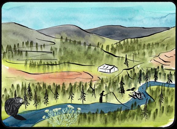
As you drive up the Dempster you can see that this is a special place. There are lots of creeks running through the area that are crystal clear. There are beavers who have called this place home for generations. Keeping the water clean is very important as this is a place where citizens fish – the water and fish must remain healthy. DRPC Commission Members |
||||
|
Special Management Directions (Recommendations to achieve Vision) |
||||
|
In addition to all applicable General Management Directions, this area is subject to: 1. The viewscape off the Dempster Highway should be maintained for its aesthetic and natural value. 2. Except for winter access, new surface access infrastructure off the Dempster Highway should be considered jointly by the Parties. 3. Heap-leach mining involves the use of chemicals, normally a cyanide solution, to extract precious metals from ore. Use of heap-leach mining practices in this area should take every precaution to not harm the surrounding aquatic environment. The collection of accurate and robust baseline data collection on groundwater and surface water quality parameters as well as continued monitoring for impacts will be important considerations for development in this area. 4. This area contains important habitat for sharp-tailed grouse, which are a species of management concern. Development in this area should be planned to minimize impacts of key habitat for sharp-tailed grouse. 5. If the mine becomes active again traffic may need to be managed to ensure the continued peaceful enjoyment of the adjacent settlement land in LMU 10: Tintina Trench (page 212). 6. Dempster Highway Corridor sub-regional plan will affect this LMU and thus interim measures and future sub-regional planning direction should be considered (see Section 5.4.3.1.1 – Dempster Highway Corridor, page 130). |
||||
|
Cumulative Effects Thresholds |
||||
|
Relative to LMU Size* |
Surface Disturbance (%) |
Linear Disturbance (km/km2) |
||
|
Current disturbance (2020) |
0.55 |
0.29 |
||
|
Precautionary |
0.5 |
0.25 |
||
|
Cautionary |
1.5 |
0.75 |
||
|
Critical |
2 |
1 |
||
|
On the ground amounts** |
Surface Disturbance (km2) |
Linear Disturbance (km) |
||
|
Current disturbance (2020) |
5.14 |
277 |
||
|
Room under cautionary threshold*** |
8.98 |
429 |
||
|
Precautionary |
4.71 |
237 |
||
|
Cautionary |
14.12 |
706 |
||
|
Critical |
18.82 |
941 |
||
|
*These are proportional to the size of the LMU, and correspond to table 3-2 of the Recommended Plan. They are measured in the % of the LMU that can be disturbed (“Surface Disturbance”) and in km/km2 (“Linear Disturbance Density”). **These are amounts that can be measured and apply to the whole LMU and would be more familiar to project proponents and regulators. They are measured in km2 of disturbance and in km of linear disturbance (e.g., roads, trails and cutlines). ***How much more disturbance can be added to existing disturbance before the cautionary threshold is reached. |
||||
Cumulative Effects Indicators
Surface Disturbance
Linear Disturbance
Precautionary |
Cautionary |
Critical |
These gauges show how much of each disturbance indicator there is in the LMU with the needle and the large number near the middle. The colours indicate disturbance level zones or “management thresholds”. If the needle is in the white zone, no threshold has been reached.
More information on our Cumulative Effects Framework is found here.

|
Priority Objectives |
|
|
ü Mineral exploration and development contribute to local employment, economic stimulus, and long-term socio-economic benefits. Opportunity for sustainable forestry that contributes to a growing diversified economy, local employment, and economic stimulus. ü Tourism and recreational experiences include scenic viewscapes, wildlife viewing, culture appreciation, and heritage education within appropriate areas of the Planning Region. ü A diverse range of sustainable recreational opportunities in the Region. Stewardship principles are consistently applied by land, water, and resource users. ü Functioning wetlands ecosystems that support ecological and socio-cultural values. ü Healthy aquatic ecosystems and watersheds. ü Key areas for harvesting in the Planning Region are maintained and protected to support both First Nations and non-First Nations use. |
|
|
Rationale for Designation |
|
|
· Area contains advanced hard rock exploration, and potential future re-processing of the ore heap at Brewery Creek · LMU contains wildlife key areas and wetlands, and is adjacent to high use areas for subsistence, cultural, and traditional economic activities. · An ISA 3 designation will allow for continued mineral exploration and development and forestry to occur without undermining the ecological and socio-cultural value of the surrounding area. |
|
|
Ecological Integrity and Conservation Value |
|
|
Birds |
Includes high elevation (>1,000 m) habitat crucial for some migratory bird species and part of the Tintina Trench flyway. Contains key wildlife areas for sharp tailed grouse. |
|
Caribou |
Overlap with Fortymile, Clear Creek and Hart River Caribou Herd ranges. Contains critical summer and winter habitat for mountain caribou, including habitat for calving, post-calving, summer, and rutting. |
|
Ecosystem Representation |
Located within McQuesten Highlands ecoregion which is not represented in Yukon’s protected areas system. |
|
Furbearers |
Contains well established key habitat for beavers. |
|
Grizzly Bear |
|
|
Landscape Connectivity |
Located within the Tintina Trench Flyway. |
|
Moose |
Extensive good moose habitat, wildlife key areas for moose later winter (February to April) habitat along Hamilton and Brewery Creeks. |
|
Salmon and other Fish |
The Klondike River provides important chinook salmon spawning habitat and salmon have been documented in the upper reaches of the river near Hamilton Creek. The Klondike River is also home to resident fish species, including Arctic grayling. |
|
Sheep |
|
|
Species at Risk |
|
|
Vegetation and Unique Features |
One identified location for Yukon Podistera, some occurrences of rare or endemic plant species, and presence of mineral licks. |
|
Water |
|
|
Wetlands |
Some limited wetland habitats within lowlands including bogs, fens, and marshes, which provide for important wildlife habitat and ecosystem services. |
|
Culture, Heritage Resources and Community Value |
|
|
Community Value |
Recreational opportunities exist off the Dempster Highway Corridor and Brewery Creek access roads. Canoeing/packrafting the North-Klondike. Off-road opportunities for hiking and sightseeing off Dempster Highway or Brewery Creek access road, opportunities for fishing, harvesting, and camping on North Klondike River. |
|
Heritage Resources and Sites |
Several archeological resources are documented in this LMU. Area contains numerous historic resources related to the Yukon North Fork Ditch. |
|
Traditional Economy / Traditional Uses |
Year-round traditional use area; important area for moose and caribou harvesting and fishing. Also, small game, birds, and berries. Wood cutting and other traditional pursuits. |
|
Socio-economic Value |
|
|
Agriculture |
|
|
Energy |
|
|
Forestry |
Overlap with the South Klondike River landscape unit of the Dawson Forest Resources Management Plan, which is designated as a medium priority for forest resource development in the short-term. This landscape unit is considered to have high timber values, and there is a completed Timber Harvest Plan for North Fork, and areas for personal as well as commercial fuel use. |
|
Mineral Resources |
Active quartz exploration and location of a past gold producing mine at Brewery Creek, which may reopen in the future. |
|
Outfitting and Trapping |
Overlap with several trapping concessions and one active outfitting concession. |
|
Tourism |
No identified high use areas for tourism, located directly adjacent to the Dempster Highway corridor, opportunities for scenic views and wildlife viewing. |
|
Transportation and Access |
Adjacent to Dempster highway corridor, contains a portion of Brewery Creek access road, and secondary trails. |