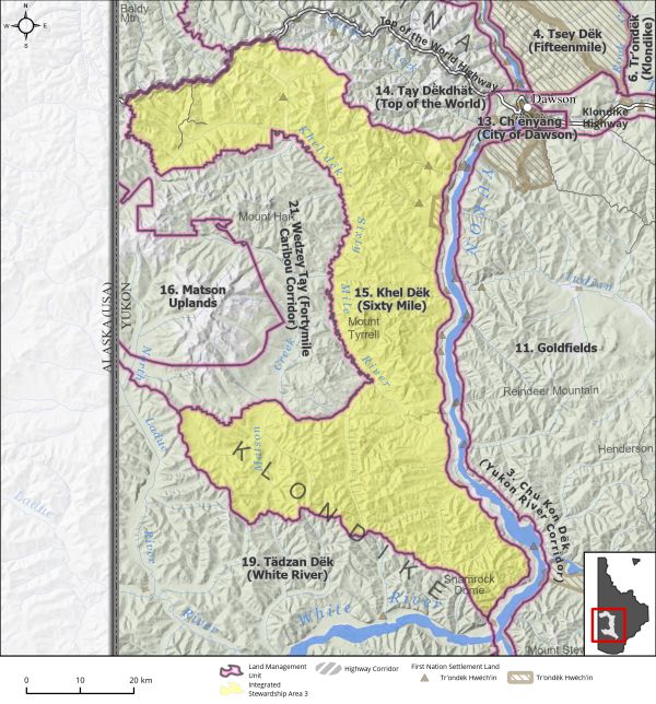
|
Land Use Designation: |
Integrated Stewardship Area 3 |
||
|
Land Status: |
Non-Settlement Land and Tr’ondëk Hwëch’in Settlement Land TH R-11A, TH R-43A, TH S-107B1, TH S-14B1, TH S-169B1, TH S-75B1 |
||
|
Area: |
2897 km2 |
Planning Region % |
7.3% |
|
|
||||
|
|
||||
|
Walking on the Land Together (Intent Statement) |
||||
|
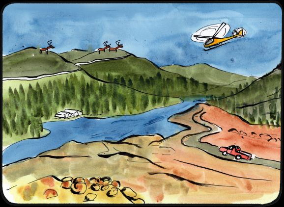
The intent for this area is to adequately protect key caribou habitat and to ensure sustainable development, through strong access management recommendations. This area is a large land mass containing major watersheds and multiple land uses, including mineral exploration and development, forestry, tourism, harvesting, and recreation. Unique to this area is the Top of the World Highway, which represents an important seasonal multi-use access corridor. Interest in this area is growing, which includes increased opportunities for access into previously remote areas. It will be important that access infrastructure is planned for and managed to ensure preservation of important environmental and socio-cultural values. |
||||
|
Tr’ëhudè (Our Way of Life) & Stewardship |
||||
|
Khel Dëk or the Sixty Mile River flows through this LMU. The Hän name ‘Khel Dëk’ means Packsack River. This is an important area for Tr’ondëk Hwëch’in, especially for harvesting activities. In the past there were camps at the mouth of the Sixty Mile River and traditional travel routes. The area is used for subsistence hunting of Fortymile caribou and there are ongoing efforts by Tr’ondëk Hwëch’in to reconnect with the herd through community hunts and educational camps. |
||||
|
Special Management Directions (Recommendations to achieve Vision) |
||||
|
In addition to all applicable General Management Directions, this area is subject to: 1. This area is located within important caribou herd ranges and considered extensive moose habitat. It is imperative to maintain key caribou migration pathways and to minimize disturbance to key (summer and winter) habitat areas, and that impacts to moose through overharvesting are minimized: a. Avoid disturbance in key caribou migration pinch points along ridges as identified by regional biologists. b. Development within the large core patches of winter habitat found adjacent to the Top of the World Highway should be avoided where possible and limited otherwise. c. Timing windows that reduce industrial impacts to moose and caribou should be applied as guided by regional biologists. d. Access management planning as per Section 5.4.3.2.2 – Access Management Planning Recommendations (page 140). 2. This area is particularly important for subsistence harvesting and the pursuit of traditional economic activities. The ability for residents to continue using the land in this way must be maintained. 3. Top of the World Highway Corridor: Direction set out in Section 5.4.3.1.2 – Top of the World Highway Corridor (page 132) should apply. |
||||
|
Cumulative Effects Thresholds |
||||
|
Relative to LMU Size* |
Surface Disturbance (%) |
Linear Disturbance (km/km2) |
||
|
Current disturbance (2020) |
0.76 |
0.36 |
||
|
Precautionary |
0.5 |
0.25 |
||
|
Cautionary |
1.5 |
0.75 |
||
|
Critical |
2 |
1 |
||
|
On the ground amounts** |
Surface Disturbance (km2) |
Linear Disturbance (km) |
||
|
Current disturbance (2020) |
21.93 |
1029 |
||
|
Room under cautionary threshold*** |
21.31 |
1133 |
||
|
Precautionary |
14.41 |
721 |
||
|
Cautionary |
43.24 |
2162 |
||
|
Critical |
57.66 |
2883 |
||
|
*These are proportional to the size of the LMU, and correspond to table 3-2 of the Recommended Plan. They are measured in the % of the LMU that can be disturbed (“Surface Disturbance”) and in km/km2 (“Linear Disturbance Density”). **These are amounts that can be measured and apply to the whole LMU and would be more familiar to project proponents and regulators. They are measured in km2 of disturbance and in km of linear disturbance (e.g., roads, trails and cutlines). ***How much more disturbance can be added to existing disturbance before the cautionary threshold is reached. |
||||
Cumulative Effects Indicators
Surface Disturbance
Linear Disturbance
Precautionary |
Cautionary |
Critical |
These gauges show how much of each disturbance indicator there is in the LMU with the needle and the large number near the middle. The colours indicate disturbance level zones or “management thresholds”. If the needle is in the white zone, no threshold has been reached.
More information on our Cumulative Effects Framework is found here.

|
Priority Objectives |
|
|
ü A resilient and growing moose population sufficient to support herd health, as well as current and future harvest levels. ü Placer and quartz mine exploration and development is carried out in a sustainable way and contributes to a growing diversified economy. ü People can access the land, water, and resources in a way that acknowledges and supports the values and minimizes conflicts and cumulative effects. ü Habitat and migration pathways are sufficient to support historic caribou population levels. ü Key areas for harvesting in the Planning Region are maintained and protected to support both First Nations and non-First Nations use. ü Continued and successful traditional land use and traditional economic activities. |
|
|
Rationale for Designation |
|
|
· Area should remain open for mineral exploration and development, which is a significant contributor to the Region’s economic and socio-cultural environment. · General management directions in Section 5 and the special management directions above should ensure adequate protection of wildlife habitat and that the multi-industrial nature of this area can co-exist with recreational and traditional pursuits. · An ISA 3 designation will allow for continued responsible and sustainable growth of industrial pursuits in this area without undermining its ecological integrity. |
|
|
Ecological Integrity and Conservation Value |
|
|
Birds |
Area of high elevation habitat (>1,000 m) which is important for some migratory bird species, and areas adjacent to the Yukon River can contain raptor nests (incl. peregrine falcon and golden eagle). Isolated areas of high concern habitat for migratory birds along major rivers and watercourses (Matson Creek and Sixty Mile River). |
|
Caribou |
Within the range of the Fortymile and Nelchina Caribou Herds and contains areas of important winter and summer habitat as well as within key migration corridors in the spring and fall. |
|
Ecosystem Representation |
Part of Klondike Plateau ecoregion of the Boreal Cordillera. |
|
Furbearers |
Areas of excellent suitability for stream dwelling beaver habitat and some good to fair suitability for pond dwelling habitat. Presence of isolated moderate to low muskrat habitat suitability. |
|
Grizzly Bear |
|
|
Landscape Connectivity |
|
|
Moose |
Extensive good moose habitat and contains several wildlife key areas for moose, predominantly for late winter (February to April). |
|
Salmon and other Fish |
No occurrence of mapped salmon spawning habitat, likely some presence of resident fish species in various watercourses within the area. |
|
Sheep |
|
|
Species at Risk |
|
|
Vegetation and Unique Features |
Presence of intact forest (>140 years old) near Mount Tyrell and Matson Creek. Occurrence of known mineral licks. |
|
Water |
|
|
Wetlands |
Wetland habitat along Sixty Mile River and Matson Creek includes bogs, fens, and swamps. |
|
Culture, Heritage Resources and Community Value |
|
|
Community Value |
Harvest of non-timber forest products is important for the community, especially along the Top of the World Highway, but also down the Sixty Mile Road and other secondary roads. Adjacency to the Top of the World Highway and the presence of several secondary roads represents significant recreational opportunities in this area, predominantly from ORV use, hiking, berry picking, wildlife viewing. |
|
Heritage Resources and Sites |
Presence of traditional trails and several archaeological sites and historical mining sites of the Sixty Mile River and Miller and Glacier Creeks. |
|
Traditional Economy / Traditional Uses |
There are several settlement lands parcels identified as important harvesting and gathering sites including S-14B. First Nation land-based connections to this area; very active harvest area for all natural resources including moose and caribou, berries, etc. along the TOW Highway and adjacent lands. |
|
Socio-economic Value |
|
|
Agriculture |
|
|
Energy |
|
|
Forestry |
Part of Sixty Mile River Landscape Unit of Dawson Forest Resources Management Plan. Area was designated for forest resource management with a medium priority for planning in the short-term. Considered to include potential for high timber values. No active timber harvest plans in the area. |
|
Mineral Resources |
Predominantly highly to significantly prospective for minerals. Placer exploration and mining is prevalent in areas as well as areas of active quartz exploration. |
|
Outfitting and Trapping |
Active trapping concessions and presence of associated infrastructure. |
|
Tourism |
Top of the World Highway adjacent, which is an important area for tourism in the Region. Most tourism activity would occur within proximity to the highway or accessed off the Yukon River. |
|
Transportation and Access |
Area is accessible via the Top of the World Highway and several secondary roads. |