|
Land Use Designation: |
Sub-regional Planning Area |
||
|
Land Status: |
Non-Settlement Land and Tr’ondëk Hwëch’in Settlement Land TH C-14B, TH C-16B, TH C-7B, TH R-14A, TH R-20A, TH R-38A, TH R-64B, TH S-106B1, TH S-113B1, TH S-122B1, TH S-126B1, TH S-153B1, TH S-165B, TH S-166B1, TH S-41B |
||
|
Area: |
198 km2 |
Planning Region % |
0.5% |
|
|
||||
|
|
||||
|
Walking on the Land Together (Intent Statement) |
||||
|
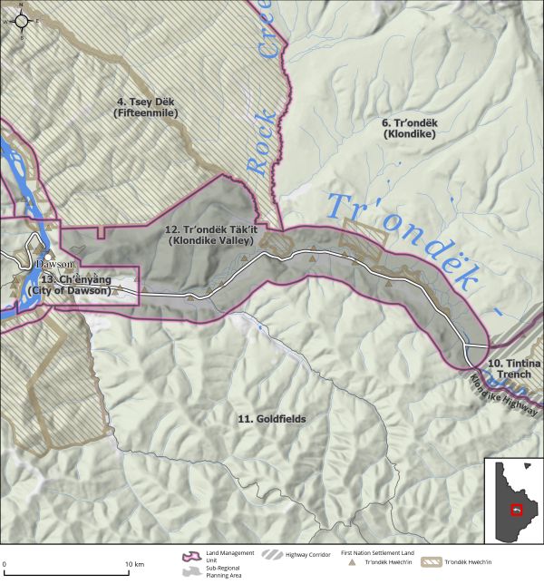
The vision for Tr’ondëk Täk’it (Klondike Valley) is a balance of residential use, trapping, agriculture, tourism, industry, infrastructure needs, traditional activities, and other activities, while conserving key wildlife habitat, a healthy watershed and clean drinking water. This area of the Planning Region contains multiple and extensive competing land interests, including residential, mining, industrial, tourism, recreational, and agricultural, as well as various wildlife and socio-cultural values. The North Klondike Highway is a critical route for transporting goods and people to the community of Dawson and further north and is thus a significant transportation corridor in the Planning Region. Due to the character of this area and the number of competing interests, sub-regional planning as per Chapter 11 of the FNFA is recommended. |
||||
|
Tr’ëhudè (Our Way of Life) & Stewardship |
||||
|
Tr’o, the first part of the Hän word Tr’ondëk and Tr’ochëk refers to the rocks or ‘hammerstones’ that were used to hammer stakes for fish weirs to catch salmon in the river. The namesake of the Klondike (Tr’ondëk) river demonstrates the importance of salmon to the Tr’ondëk Hwëch’in (Dobrowolsky, 2014). Commission members recalled stories of the Tr’ondëk being full of big king salmon which were a bright ruby red colour and in numbers so great that it seemed as though you could walk across the river on them. “These things are all connected and when you learn language you start digging into the past.” Angie Joseph-Rear, DRPC Commission Member |
||||
|
Special Management Directions (Recommendations to achieve Vision) |
||||
|
In addition to all applicable General Management Directions, this area is subject to: 1. Interim measures – applied upon Plan approval until sub-regional plan approved 1. This LMU is exempt from surface and linear disturbance tracking as the appropriate indicators will be selected during the sub-regional planning process. 2. New spot land applications for permanent dispositions should be discouraged. a. If a land disposition is permitted to proceed, development should first be considered within or close to existing settlement areas (i.e., the City of Dawson, Bear Creek, Rock Creek, and Henderson Corner). b. New residential development in areas of high potential for agriculture, forestry and/or mineral exploration should be discouraged. c. Access to existing recreational trails should be maintained and where land use conflicts occur, appropriate mitigations put in place. d. Impacts to fish in the Klondike River, in particular salmon, should be mitigated. 3. Ensure Tr’ondëk Hwëch’in citizens have continued use and peaceful enjoyment of Settlement Land, as per the THFA. Particular attention should be given to Settlement Lands that intersect with other LMUs, such as R64B, R38A, S11B1 and C14B. 4. City of Dawson expansion may occur before sub-regional planning is completed. The Parties should work with the City of Dawson to ensure LMU values are not negatively impacted. 5. Mitigate potential harmful impacts to the Klondike River watershed and City of Dawson municipal water supply catchment area (see Section 5.3.5.1 – Community Water, page 118). 6. High value agricultural land should be prioritized for agricultural purposes. 2. Sub-regional Planning 1. To be conducted jointly by the Parties as per Chapter 11 of the THFA and initiated within 3 years of Plan approval. a. Sub-regional planning should be undertaken by the existing DRPC or a new specific sub-regional planning commission which should be comprised of residents from the planning area and the Dawson community. b. Collaboration with other planning partners is encouraged, and this includes the City of Dawson, the Klondike Development Organisation, and the Tr’ondëk Hwëch’in Community Development Corporation. 2. Establishment of new Klondike Valley zoning guidelines to regulate future land use activities and help ensure land use conflicts are avoided. a. Identify areas suitable for new residential development, including expansion of existing residential areas e.g., City of Dawson, Bear Creek, Rock Creek, Henderson’s Corner. b. Ensure areas of “high” (Class 3 to 5) agricultural potential are prioritized for agricultural and accessory uses to enhance food security in the Region. c. Determine the need for future commercial and industrial land uses and identify appropriate areas. d. Identify areas that have potential for mixed or multiple land uses, such as agriculture and mineral development. e. Identify new and preserve existing recreation areas. This includes walking/biking trails and outdoor aquatic amenities. f. Identify areas that are appropriate for renewable energy generation. 3. Complement planning and development of the City of Dawson municipality. 4. Complement planning and development of the Central Tr’ondëk Land Management Area. 5. Ensure Tr’ondëk Hwëch’in citizens have continued use and peaceful enjoyment of Settlement Land, as per the THFA. Particular attention should be given to Settlement Lands that intersect with other LMUs, such as R64B, R38A, S11B1 and C14B. 6. Consider the potential impacts of climate change, particularly regarding flooding around residential areas, wildlife habitats, and permafrost slumping. 7. Ensure City of Dawson municipal water supply is protected, and land uses that could lead to contamination be discouraged within the catchment area. 8. Consider how residential growth may impact services offered within the City of Dawson and municipal tax ratepayers. 9. Climate Change mitigations and adaptations: a. Consideration of the potential effects of climate change in the area including (but not limited to) flooding, landslide potential, slumping, and permafrost degradation. b. Proposed renewable energy projects must consider LMU values, interim measures as outlined in this section, and adjacent LMUs. |
||||
|
Cumulative Effects Thresholds |
||||
|
Relative to LMU Size* |
Surface Disturbance (%) |
Linear Disturbance (km/km2) |
||
|
Current disturbance (2020) |
3.76 |
1.71 |
||
|
Precautionary |
NA |
NA |
||
|
Cautionary |
NA |
NA |
||
|
Critical |
NA |
NA |
||
|
On the ground amounts** |
Surface Disturbance (km2) |
Linear Disturbance (km) |
||
|
Current disturbance (2020) |
7.5 |
339.4 |
||
|
Room under cautionary threshold*** |
NA |
NA |
||
|
Precautionary |
NA |
NA |
||
|
Cautionary |
NA |
NA |
||
|
Critical |
NA |
NA |
||
|
*These are proportional to the size of the LMU, and correspond to table 3-2 of the Recommended Plan. They are measured in the % of the LMU that can be disturbed (“Surface Disturbance”) and in km/km2 (“Linear Disturbance Density”). **These are amounts that can be measured and apply to the whole LMU and would be more familiar to project proponents and regulators. They are measured in km2 of disturbance and in km of linear disturbance (e.g., roads, trails and cutlines). ***How much more disturbance can be added to existing disturbance before the cautionary threshold is reached. |
||||
|
Priority Objectives |
|
|
ü A diverse range of sustainable recreational opportunities in the Region. ü A broad understanding by land and resource users of different concepts of stewardship. ü Availability of potable water. ü Community growth can occur in a sustainable way, while respecting ecological, social and cultural values. ü Consistent with Our Clean Future (2020d): o Less greenhouse emissions. o Access to reliable and affordable renewable energy. o Adapt to impacts of climate change. o Green economy. |
|
|
Rationale for Designation |
|
|
A sub-regional plan under Chapter 11 is an appropriate avenue for planning for this multi-purpose area. Until then, adherence to the recommended special management directions above will ensure the overall management intent of the area is met. |
|
|
Ecological Integrity and Conservation Value |
|
|
Birds |
Presence of raptor nests along Klondike River and watercourses and ponds offer important habitat for waterfowl, including swans, cranes, ducks, geese, and shorebirds. |
|
Caribou |
Within the range of the Fortymile Caribou Herd but the area is unlikely to offer habitat values for caribou. |
|
Ecosystem Representation |
|
|
Furbearers |
Beaver and muskrat areas, lesser occurrence of wolverine, ermine, and river otter. Considered to be a regionally important lynx refugium, in which when lynx populations in surrounding areas decline, lynx populations in the Klondike valley and surroundings do not. As such, this area can be considered a significant seed source for regional lynx habitats. |
|
Grizzly Bear |
|
|
Landscape Connectivity |
|
|
Moose |
Area represents important habitat and corridor for moose and vehicle collisions are frequent. |
|
Salmon and other Fish |
The Klondike River watershed offers critical habitat requirements for chinook salmon (spawning, rearing) and important habitat for resident fish species including Arctic grayling. |
|
Sheep |
|
|
Species at Risk |
|
|
Vegetation and Unique Features |
|
|
Water |
Klondike River watershed offers important aquatic habitat values for key wildlife in the Region as well an important drinking water source for residents of the Region. |
|
Wetlands |
Presence of some wetland habitat near North Klondike Highway. |
|
Culture, Heritage Resources and Community Value |
|
|
Community Value |
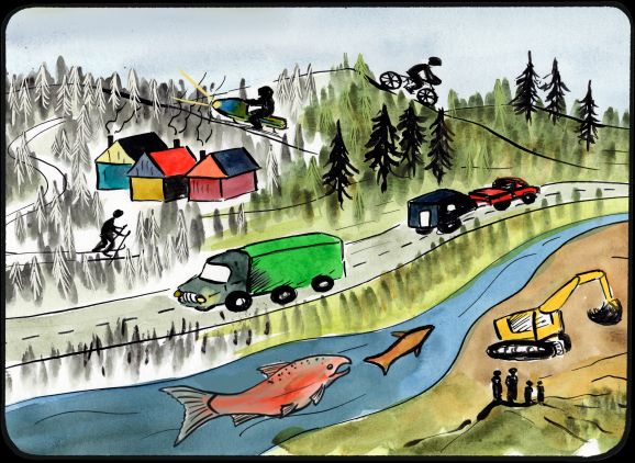
Residential: Area of highest priority for current and future residential development. Recreation: Area of high priority for recreational pursuits given high residential use, proximity to the North Klondike Highway, and City of Dawson. Recreation in this area includes walking, biking, hiking, swimming, fishing, ORV use, etc. |
|
Heritage Resources and Sites |
Occurrence of recorded historic resources, archaeological sites, and parts of traditional trails. Includes dredge piles of historical significance as well as sites associated with agricultural history and North Fork Ditch. |
|
Traditional Economy / Traditional Uses |
High cultural value and contemporary use for traditional economic activities, includes important Tr’ondëk Hwëch’in community sites. Due to its proximity to the City of Dawson, it is an important traditional use area for connecting to the land and maintaining Tr’ondëk Hwëch’in way of life. |
|
Socio-economic Value |
|
|
Agriculture |
High agricultural potential in the area given proximity to the City of Dawson as well as suitable land for growing. |
|
Energy |
Potential for renewable energy infrastructure. |
|
Forestry |
High commercial fuelwood harvesting value. Overlaps with Dome Road Timber Harvest Plan. |
|
Mineral Resources |
Highly to significantly prospective, presence of mineral claims and of significant interest to both placer and hard rock operators. |
|
Outfitting and Trapping |
Presence of active trapping concession and associated infrastructure. |
|
Tourism |
High tourism value given proximity to the North Klondike Highway and to the City of Dawson for hiking, gold rush history viewing, etc. |
|
Transportation and Access |
The North Klondike Highway is the major transportation route in the Region. |