|
Land Use Designation: |
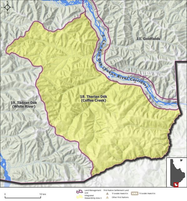
Integrated Stewardship Area 3 |
||
|
Land Status: |
Non-Settlement Land |
||
|
Area: |
998 km2 |
Planning Region % |
2.5% |
|
|
||||
|
|
||||
|
Walking on the Land Together (Intent Statement) |
||||
|
The vision for this area will focus on sustainable development by means of cumulative effects management, access management, and the preservation of key values. It is important that this area remain open for current and future mineral interests without undermining its important environmental and cultural attributes. This area hosts an active advanced hard rock exploration program with associated infrastructure, and the site of a potential hard rock mine. It is also the location of important habitat and migration corridors for the Fortymile Caribou and Nelchina Caribou Herds. While existing access in this area remains relatively unconnected to the Goldfields LMU, the proposed Northern Access Route would create substantial opportunities for increased accessibility. |
||||
|
Tr’ëhudè (Our Way of Life) & Stewardship |
||||
|
In Hän, Ttthetryän Dëk means ‘copper creek’ and is named so because the Coffee Creek area was a source for copper. Copper was used for making copper knives and jewellery pre-contact. “There are traditional routes and trails in this area that connected the people of Tr’ondëk Hwëch’in to the people of Alaska. The people of Alaska were the keepers of Tr’ondëk Hwëch’in songs and dances, ‘The connection to Alaska is a connection to our language, traditions, and culture.’” Angie Joseph-Rear, DRPC Commission Member |
||||
|
Special Management Directions (Recommendations to achieve Vision) |
||||
|
In addition to all applicable General Management Directions, this area is subject to: 1. Area contains important caribou migration routes and ridgetops. Yukon Government and Tr’ondëk Hwëch’in to identify appropriate conditions to minimize impacts to these areas from future development. 2. Adjacent to this LMU there are small, isolated sheep populations that are particularly sensitive to disturbance. Access via land and air into this area should take every precaution to minimize disturbance to sheep. 3. Efforts to enhance the use of this area for traditional economic activities and cultural/educational pursuits should be explored 4. Heap-leach mining involves the use of chemicals, normally a cyanide solution, to extract precious metals from ore. Use of heap-leach mining practices in this area should take every precaution to not harm the surrounding aquatic environment. The collection of accurate and robust baseline data collection on groundwater and surface water quality parameters as well as continued monitoring for impacts will be important considerations for development in this area. |
||||
|
Cumulative Effects Thresholds |
||||
|
Relative to LMU Size* |
Surface Disturbance (%) |
Linear Disturbance (km/km2) |
||
|
Current disturbance (2020) |
0.41 |
0.16 |
||
|
Precautionary |
0.5 |
0.25 |
||
|
Cautionary |
1.5 |
0.75 |
||
|
Critical |
2 |
1 |
||
|
On the ground amounts** |
Surface Disturbance (km2) |
Linear Disturbance (km) |
||
|
Current disturbance (2020) |
4.08 |
157 |
||
|
Room under cautionary threshold*** |
10.87 |
590 |
||
|
Precautionary |
4.98 |
249 |
||
|
Cautionary |
14.95 |
747 |
||
|
Critical |
19.93 |
997 |
||
|
*These are proportional to the size of the LMU, and correspond to table 3-2 of the Recommended Plan. They are measured in the % of the LMU that can be disturbed (“Surface Disturbance”) and in km/km2 (“Linear Disturbance Density”). **These are amounts that can be measured and apply to the whole LMU and would be more familiar to project proponents and regulators. They are measured in km2 of disturbance and in km of linear disturbance (e.g., roads, trails and cutlines). ***How much more disturbance can be added to existing disturbance before the cautionary threshold is reached. |
||||
Cumulative Effects Indicators
Surface Disturbance
Linear Disturbance
Precautionary |
Cautionary |
Critical |
These gauges show how much of each disturbance indicator there is in the LMU with the needle and the large number near the middle. The colours indicate disturbance level zones or “management thresholds”. If the needle is in the white zone, no threshold has been reached.
More information on our Cumulative Effects Framework is found here.

|
Priority Objectives |
|
|
ü Habitat and migration pathways are sufficient to support historic population levels. ü Placer and quartz mine exploration and development is carried out in a sustainable way and contributes to a growing diversified economy. ü Mineral exploration and development contribute to local employment, economic stimulus, and long-term socio-economic benefits. ü People are able to access the land, water, and resources in a way that acknowledges and supports the values in the LMU and minimizes conflicts and cumulative effects. |
|
|
Rationale for Designation |
|
|
· Area contains an active mineral exploration and potential mine site and ensuring that there is an adequate land base for mining to continue as a key economic development activity in the Planning Region is important. · The area also contains key habitat for caribou and sites of cultural history and significance to Tr’ondëk Hwëch’in. · An ISA 3 designation with special management directions should meet the management intent for this area. |
|
|
Ecological Integrity and Conservation Value |
|
|
Birds |
Presence of high elevation habitat (>1,000 m) important for some migratory bird species. |
|
Caribou |
Within the range of the Fortymile, Nelchina, and Klaza Caribou Herds. Contains important summer and winter habitat, as well as key ridges for migratory caribou in the spring and fall. |
|
Ecosystem Representation |
|
|
Furbearers |
|
|
Grizzly Bear |
|
|
Landscape Connectivity |
|
|
Moose |
Contains good habitat for moose. |
|
Salmon and other Fish |
Watercourses are likely to contain resident fish species. |
|
Sheep |
Considered to contain scattered sheep habitat generally and adjacent to isolated sheep populations along Yukon and White rivers. |
|
Species at Risk |
|
|
Vegetation and Unique Features |
Presence of some intact forests (>140 years old). |
|
Water |
Contains tributaries to Yukon River. |
|
Wetlands |
Some wetland habitat identified on small tributaries to Yukon River, including swamp and fen. |
|
Culture, Heritage Resources and Community Value |
|
|
Community Value |
Low recreation potential except for limited use along the Yukon River. |
|
Heritage Resources and Sites |
Presence of archaeological sites and recorded historic resources near Yukon River and area contains cultural significance to Tr’ondëk Hwëch’in. |
|
Traditional Economy / Traditional Uses |
This LMU has considerable historical value, along with present day use and future potential for harvesting, trapping, and hunting. Important areas for connecting to the land through the practice of land use activities. This area is important for maintaining Tr’ondëk Hwëch’in way of life and connections to the land. |
|
Socio-economic Value |
|
|
Agriculture |
|
|
Energy |
|
|
Forestry |
Within the Yukon River South landscape unit for the Dawson Forest Resource Management Plan, which has been designated for a medium priority for long-term planning, as the area has a higher conservation focus. |
|
Mineral Resources |
Highly prospective, and the sight of significant mineral exploration and development. Area contains an advanced hard rock exploration project and potential future hard rock mine site. |
|
Outfitting and Trapping |
Overlapping trapping concessions. |
|
Tourism |
|
|
Transportation and Access |
Not currently accessible via land but contains considerable access from past and contemporary mineral exploration and development in area. Northern Access Road will result in increased access into this LMU. |