|
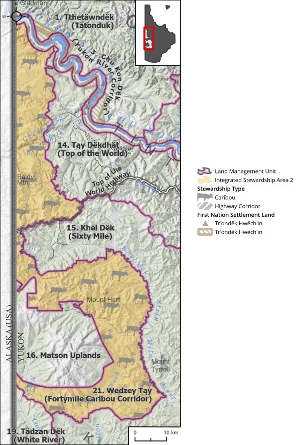
Integrated Stewardship Area 2 |
|||
|
Land Status: |
Non-Settlement Land and Tr’ondëk Hwëch’in Settlement Land TH S-13B1 |
||
|
Area: |
2021km2 |
Planning Region % |
5.1% |
|
|
||||
|
|
||||
|
Walking on the Land Together (Intent Statement) |
||||
|
Aligning with the Special Management Area identified within LMU 16: Wëdzey Nähuzhi (Matson Uplands) (page 244), the intent for the Fortymile caribou corridor is to adequately preserve habitat requirements and migration routes for the Fortymile Caribou Herd, while allowing for limited development. Future management of this area should continue to support the ongoing health and population of the Fortymile Caribou Herd and as such continued quartz mining activity is not currently envisioned in this LMU. This will help to ensure that Tr’ondëk Hwëch’in harvest rights and stewardship responsibilities are not compromised. |
||||
|
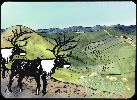
Tr’ëhudè (Our Way of Life) & Stewardship |
||||
|
Caribou have provided food, traditional supplies/tools, and clothing for the Tr’ondëk Hwëch’in people for thousands of years, and it is critical that this connection remain for future generations. As stewards of this land, it is crucial that the Tr’ondëk Hwëch’in protect caribou and their habitat as it is a part of cultural continuity and a way of life. Tr’ondëk Hwëch’in did not harvest the Fortymile Caribou herd for decades due to the depletion of the herd. In recent years the herd has rebounded to some extent and the Tr’ondëk Hwëch’in have recently started to rebuild a cultural connection through subsistence harvesting activities. Adapted from Tr’ondëk Hwëch’in Review of the Dawson Regional Draft Plan, 2021 |
||||
|
Special Management Directions (Recommendations to achieve Vision) |
||||
|
In addition to all applicable General Management Directions, this area is subject to: 1. Caribou Stewardship Overlay area (see Section 3.2.4.1 – Caribou Stewardship Area, page 44). 2. Interim withdrawal of all lands from quartz staking until Plan review or such a time as both Parties agree to remove withdrawal. 3. When a claim expires it should be withdrawn from further staking while interim withdrawal is in place. 4. Industrial Land Use: a. Under the current regulatory system quartz exploration and development is not supported in this LMU (see Rationale for Designation below). b. Other development in this area should take special precautions to ensure minimal disturbance to caribou, their habitat, and migration routes. This includes but is not limited to: i. Application of timing windows for caribou as determined by the Parties. ii. Project proponents to work with the Parties to identify, and avoid, areas with suitable lichen habitat prior to undertaking mineral development activities. iii. Reclamation standards should be applied that maximise the regrowth of caribou suitable habitat, including lichen, and avoidance of reclamation that leads to dense, wide thickets of willow in major creek or river bottoms. iv. Projects must include specific wildlife monitoring and mitigation plans that consider impacts to caribou, and at a minimum, establish a phased approach to actions taken when caribou are present. v. Development should consider guidance provided in wildlife management plans as applicable to this LMU (I.e., FMC Management Plan [pending]). 5. Industrial land use permitted within ISA 2 cumulative effects thresholds. 6. Fire suppression options should be considered in areas and implemented if deemed necessary by the Parties to protect important caribou habitat (especially lichen areas) as a response to the potential increase in and intensity of fire activity due to climate change. 7. Access: a. Continued use of existing surface access is allowed. b. New surface access is allowed within the linear density threshold of ISA 2. c. Top of the World Highway Corridor: Direction set out in Section 5.4.3.1.2 – Top of the World Highway Corridor (page 132) should apply. |
||||
|
Cumulative Effects Thresholds |
||||
|
Relative to LMU Size* |
Surface Disturbance (%) |
Linear Disturbance (km/km2) |
||
|
Current disturbance (2020) |
0.16 |
0.30 |
||
|
Precautionary |
0.25 |
0.125 |
||
|
Cautionary |
0.75 |
0.375 |
||
|
Critical |
1 |
0.5 |
||
|
On the ground amounts** |
Surface Disturbance (km2) |
Linear Disturbance (km) |
||
|
Current disturbance (2020) |
3.23 |
607 |
||
|
Room under cautionary threshold*** |
11.93 |
151 |
||
|
Precautionary |
5.05 |
253 |
||
|
Cautionary |
15.16 |
758 |
||
|
Critical |
20.21 |
1010 |
||
|
*These are proportional to the size of the LMU, and correspond to table 3-2 of the Recommended Plan. They are measured in the % of the LMU that can be disturbed (“Surface Disturbance”) and in km/km2 (“Linear Disturbance Density”). **These are amounts that can be measured and apply to the whole LMU and would be more familiar to project proponents and regulators. They are measured in km2 of disturbance and in km of linear disturbance (e.g., roads, trails and cutlines). ***How much more disturbance can be added to existing disturbance before the cautionary threshold is reached. |
||||
Cumulative Effects Indicators
Surface Disturbance
Linear Disturbance
Precautionary |
Cautionary |
Critical |
These gauges show how much of each disturbance indicator there is in the LMU with the needle and the large number near the middle. The colours indicate disturbance level zones or “management thresholds”. If the needle is in the white zone, no threshold has been reached.
More information on our Cumulative Effects Framework is found here.

|
Priority Objectives |
|
|
ü Healthy and resilient caribou herd populations that grow towards historic levels. ü Caribou habitat and migration pathways are sufficient to support historic population levels. ü A society that respects and is connected to caribou. ü Sustainable fish and wildlife populations supported by healthy aquatic and terrestrial habitats. ü Continued and successful traditional land use and traditional economic activities. ü Honour the harvesting and fish and wildlife management customs of First Nations people and provide for ongoing needs for fish and wildlife (Chapter 16 FNFA). ü Stewardship principles are consistently applied by land, water, and resource users. |
|
|
Rationale for Designation |
|
|
· Caribou herds across the continent are in a state of decline. Under the existing mining legislation and technology, the Commission is concerned that quartz mining activity will cause a significant negative impact to the caribou herd, especially on ridgetops which are the predominant migratory pathway. The Fortymile Caribou Herd overlaps areas of high human-caused disturbance. The herd is at significant risk of experiencing a cumulative impact from existing and proposed development. Major issues facing the herd are barriers to movement and loss of habitat. As such, key caribou migration pathways must be maintained, and disturbance to key caribou (summer and winter) habitat areas, should be minimized. · Existing mining legislation is out of date and does not provide adequate management tools. Successor legislation is in development and may provide better management tools. · Mining methods/technology applied in Yukon is a concern to the Commission, as evidenced by recent and ongoing mining projects. The Commission is hopeful that greener technologies will one day be available. · The location of this LMU within critical caribou habitat and migration corridors warrants strong direction as to where, when, and what development can happen. Ridgetops are important migration pathways for the Fortymile Caribou Herd and thus quartz exploration and development on these ridgetops is not conducive to achieve the Regional Plan’s caribou objectives (see above). · Strong special management direction and restricting new disturbance should ensure minimal impacts to the Fortymile Caribou Herd in this area. · Tr’ondëk Hwëch’in rights to harvest the Fortymile Caribou Herd in this area must not be compromised, particularly within areas adjacent to the Top of the World Highway. · Given the uncertain state of the Fortymile Caribou Herd with respect to the international migration paths, the Precautionary Principle is applicable in this case. |
|
|
Ecological Integrity and Conservation Value |
|
|
Birds |
Contains areas of high elevation habitat (>1,000 m) which is important for some migratory bird species. |
|
Caribou |
Within the range of the Fortymile and Nelchina Caribou Herds, and contains areas of important winter and summer habitat as well as within key migration corridors in the spring and fall, and the key summer corridor for Fortymile caribou. |
|
Ecosystem Representation |
Part of Klondike Plateau ecoregion. |
|
Furbearers |
|
|
Grizzly Bear |
|
|
Landscape Connectivity |
Caribou corridor to serve as a low development high conservation priority buffer for LMU 16 Matson Uplands. |
|
Moose |
Considered good habitat for moose in lowlands. |
|
Salmon and other Fish |
|
|
Sheep |
|
|
Species at Risk |
Known occurrence of Yukon Podistera. |
|
Vegetation and Unique Features |
Contains areas of high elevation habitat (>1,000 m) which is important for some migratory bird species. |
|
Water |
|
|
Wetlands |
Wetland habitat along major watercourse, including bogs, fens, and swamps. |
|
Culture, Heritage Resources and Community Value |
|
|
Community Value |
Adjacency to the Top of the World Highway and presence of several secondary roads represents significant recreational opportunities in this area, predominately from ORV use, hiking, berry picking, wildlife viewing, and winter recreation. |
|
Heritage Resources and Sites |
Presence of traditional routes (Glacier Creek) and several archaeological sites. |
|
Traditional Economy / Traditional Uses |
First Nation land-based connections to this area; active harvest area for all natural resources including moose and caribou, berries and medicines. |
|
Socio-economic Value |
|
|
Agriculture |
|
|
Energy |
|
|
Forestry |
Part of Sixty Mile River Landscape Unit of Dawson Forest Resources Management Plan. Area was designated for forest resource management with a medium priority for planning in the short-term. Considered to include potential for high timber values. No active timber harvest plans in the area. |
|
Mineral Resources |
Predominately considered moderately prospective for minerals with pockets of high to significant potential. Placer exploration and mining is prevalent in the area as well as areas of active quartz exploration. |
|
Outfitting and Trapping |
Active trapping concessions and presence of associated infrastructure. |
|
Tourism |
Top of the World Highway adjacent, which is an important area for tourism in the Region. Most tourism activity would occur within proximity to the highway or accessed off the Yukon River. Activities include wildlife viewing, winter recreation, etc. |
|
Transportation and Access |
Roads and trails are present in this LMU in addition to the Top of the World Highway. |
|
Priority Objectives |
|
|
ü Healthy and resilient caribou herd populations that grow towards historic levels. ü Caribou habitat and migration pathways are sufficient to support historic population levels. ü A society that respects and is connected to caribou. ü Sustainable fish and wildlife populations supported by healthy aquatic and terrestrial habitats. ü Continued and successful traditional land use and traditional economic activities. ü Honour the harvesting and fish and wildlife management customs of First Nations people and provide for ongoing needs for fish and wildlife (Chapter 16 FNFA). ü Stewardship principles are consistently applied by land, water, and resource users. |
|
|
Rationale for Designation |
|
|
· Caribou herds across the continent are in a state of decline. Under the existing mining legislation and technology, the Commission is concerned that quartz mining activity will cause a significant negative impact to the caribou herd, especially on ridgetops which are the predominant migratory pathway. The Fortymile Caribou Herd overlaps areas of high human-caused disturbance. The herd is at significant risk of experiencing a cumulative impact from existing and proposed development. Major issues facing the herd are barriers to movement and loss of habitat. As such, key caribou migration pathways must be maintained, and disturbance to key caribou (summer and winter) habitat areas, should be minimized. · Existing mining legislation is out of date and does not provide adequate management tools. Successor legislation is in development and may provide better management tools. · Mining methods/technology applied in Yukon is a concern to the Commission, as evidenced by recent and ongoing mining projects. The Commission is hopeful that greener technologies will one day be available. · The location of this LMU within critical caribou habitat and migration corridors warrants strong direction as to where, when, and what development can happen. Ridgetops are important migration pathways for the Fortymile Caribou Herd and thus quartz exploration and development on these ridgetops is not conducive to achieve the Regional Plan’s caribou objectives (see above). · Strong special management direction and restricting new disturbance should ensure minimal impacts to the Fortymile Caribou Herd in this area. · Tr’ondëk Hwëch’in rights to harvest the Fortymile Caribou Herd in this area must not be compromised, particularly within areas adjacent to the Top of the World Highway. · Given the uncertain state of the Fortymile Caribou Herd with respect to the international migration paths, the Precautionary Principle is applicable in this case. |
|
|
Ecological Integrity and Conservation Value |
|
|
Birds |
Contains areas of high elevation habitat (>1,000 m) which is important for some migratory bird species. |
|
Caribou |
Within the range of the Fortymile and Nelchina Caribou Herds, and contains areas of important winter and summer habitat as well as within key migration corridors in the spring and fall, and the key summer corridor for Fortymile caribou. |
|
Ecosystem Representation |
Part of Klondike Plateau ecoregion. |
|
Furbearers |
|
|
Grizzly Bear |
|
|
Landscape Connectivity |
Caribou corridor to serve as a low development high conservation priority buffer for LMU 16 Matson Uplands. |
|
Moose |
Considered good habitat for moose in lowlands. |
|
Salmon and other Fish |
|
|
Sheep |
|
|
Species at Risk |
Known occurrence of Yukon Podistera. |
|
Vegetation and Unique Features |
Contains areas of high elevation habitat (>1,000 m) which is important for some migratory bird species. |
|
Water |
|
|
Wetlands |
Wetland habitat along major watercourse, including bogs, fens, and swamps. |
|
Culture, Heritage Resources and Community Value |
|
|
Community Value |
Adjacency to the Top of the World Highway and presence of several secondary roads represents significant recreational opportunities in this area, predominately from ORV use, hiking, berry picking, wildlife viewing, and winter recreation. |
|
Heritage Resources and Sites |
Presence of traditional routes (Glacier Creek) and several archaeological sites. |
|
Traditional Economy / Traditional Uses |
First Nation land-based connections to this area; active harvest area for all natural resources including moose and caribou, berries and medicines. |
|
Socio-economic Value |
|
|
Agriculture |
|
|
Energy |
|
|
Forestry |
Part of Sixty Mile River Landscape Unit of Dawson Forest Resources Management Plan. Area was designated for forest resource management with a medium priority for planning in the short-term. Considered to include potential for high timber values. No active timber harvest plans in the area. |
|
Mineral Resources |
Predominately considered moderately prospective for minerals with pockets of high to significant potential. Placer exploration and mining is prevalent in the area as well as areas of active quartz exploration. |
|
Outfitting and Trapping |
Active trapping concessions and presence of associated infrastructure. |
|
Tourism |
Top of the World Highway adjacent, which is an important area for tourism in the Region. Most tourism activity would occur within proximity to the highway or accessed off the Yukon River. Activities include wildlife viewing, winter recreation, etc. |
|
Transportation and Access |
Roads and trails are present in this LMU in addition to the Top of the World Highway. |