|
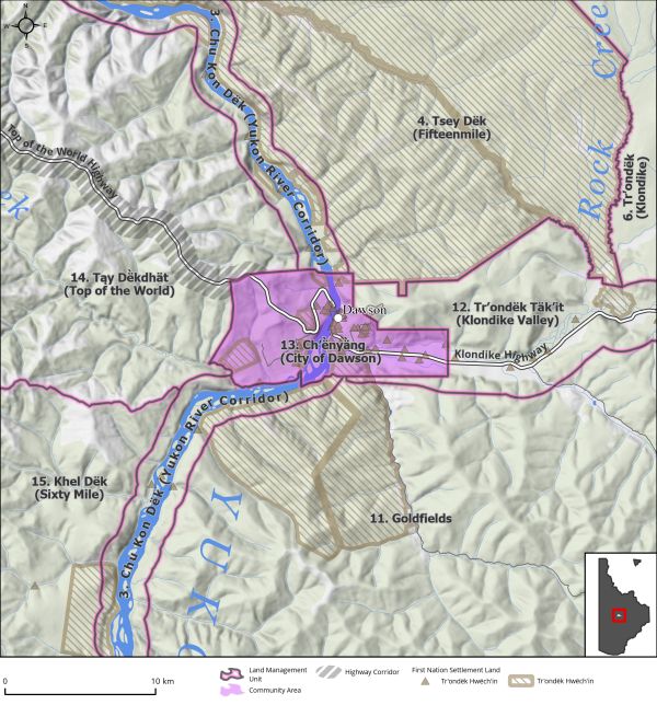
Land Use Designation: |
Community Area |
||
|
Land Status: |
Non-Settlement Land and 75 Tr’ondëk Hwëch’in Settlement Land parcels |
||
|
Area: |
81 km2 |
Planning Region % |
0.2% |
|
The Regional Land Use Plan will not apply to land within the City of Dawson and areas subject to subdivision planning or local area planning outside of a municipal boundary (including West Dawson and Sunnydale). However, the Dawson Regional Planning Commission is to consider adjacent areas, their designations, and land uses, in the development of their Plan. See also: LMU 12: Tr’ondëk Täk’it (Klondike Valley), page 224. |
|||
|
|
||
|
|
||
|
Cumulative Effects Thresholds |
||
|
Relative to LMU Size* |
Surface Disturbance (%) |
Linear Disturbance (km/km2) |
|
Current disturbance (2020) |
13.66 |
2.56 |
|
Precautionary |
NA |
NA |
|
Cautionary |
NA |
NA |
|
Critical |
NA |
NA |
|
On the ground amounts** |
Surface Disturbance (km2) |
Linear Disturbance (km) |
|
Current disturbance (2020) |
11.1 |
208.4 |
|
Room under cautionary threshold*** |
NA |
NA |
|
Precautionary |
NA |
NA |
|
Cautionary |
NA |
NA |
|
Critical |
NA |
NA |