|
Land Use Designation: |
Integrated Stewardship Area 2 |
||
|
Land Status: |
Non-Settlement Land and Tr’ondëk Hwëch’in Settlement Land Parcels TH S-90B1, TH S186B1, TH S-12B1, TH R-23A, TH R-9A, TH R-71A, TH R-24A, TH R125A |
||
|
Area: |
1,574 km2 |
Planning Region % |
3.9% |
|
|
||||
|
|
||||
|
Walking on the Land Together (Intent Statement) |
||||
|
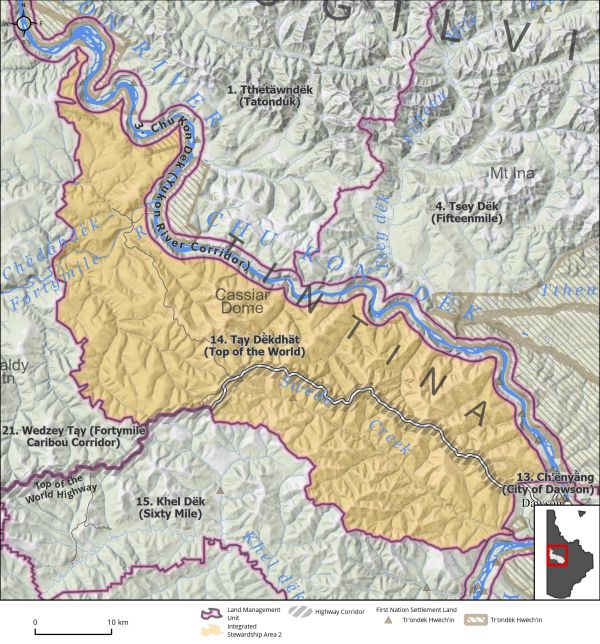
The vision for this area is to maintain and enhance its cultural and community values while allowing for limited sustainable development to continue. This LMU hosts active placer mining, forestry, tourism, traplines, harvesting, Fortymile caribou habitat, and all-season recreational pursuits along the Fortymile River and off the highway. The Top of the World Highway (TOW) runs through this LMU and thus it is highly accessible by the Highway and secondary roads and trails off the highway. The Top of the World is a major tourist route and is a route to a U.S.A border crossing. The LMU is also an area of cultural significance to Tr’ondëk Hwëch’in and continues to offer an important recreational gathering space for residents of the Planning Region and visitors alike. Given LMU Tąy Dë̀kdhät’s (Top of the World) proximity to the City of Dawson, as well as the neighbourhoods of West Dawson and Sunnydale, this area represents important opportunities for community growth, connection, and wellness that must be considered alongside any industrial uses. Chu Ttho Dëk (Swede Creek) particularly is an important source of drinking water for the community and in Hän means ‘yellow water creek’. Future management of this area will continue to focus on respectful tourism, mining, and opportunities for cultural connections. Continued enjoyment of the traditional and recreational pursuits that the area offers residents and visitors alike, with a relatively low development threshold. |
||||
|
Tr’ëhudè (Our Way of Life) & Stewardship |
||||
|
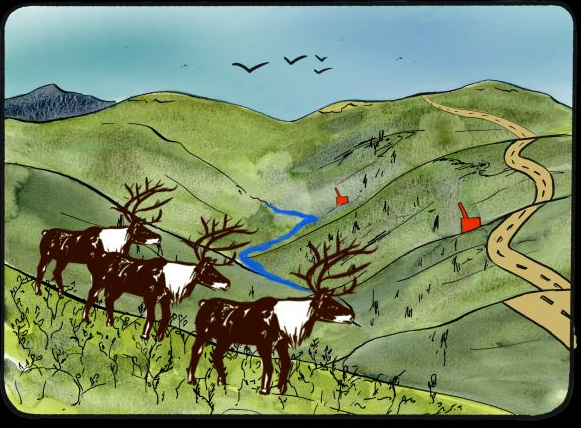
This area is important to Tr’ondëk Hwëch’in for many reasons, but particularly it is a space for reconnection. For many years, the Tr’ondëk Hwëch’in have not harvested the Fortymile caribou to help the herd to become healthy again. An entire generation of citizens have not harvested the caribou and the cultural impact of this can be felt. The opportunity for knowledge transfer and reconnection to a traditional practice and way of life is important in Tąy Dë̀kdhät (Top of The World). The name Tąy Dë̀kdhät means ‘trail on top/high’ and this route (the Top of the World Highway) is essential for connecting to families and communities in Alaska and access for community members to pursue on-the-land activities. |
||||
|
Special Management Directions (Recommendations to achieve Vision) |
||||
|
In addition to all applicable General Management Directions, this area is subject to: 1. Activities that have the potential to disturb salmon and other fish spawning sites should be restricted during known species-dependent freshwater timing windows for the Yukon (as per DFO). 2. The operation of large, high-powered tourist watercraft on the Fortymile River should not result in appreciable mortality to juvenile or adult salmon, or disruption of their habitats. 3. Land users working in proximity to Mickey Creek and Swede Creek should be made aware of the stream’s use for human consumption. An appropriate buffer should be explored and implemented where appropriate to ensure no negative impacts to these important water sources. 4. The Clinton Creek asbestos mine was abandoned in 1978 and is now under the care and maintenance of Government of Yukon and Government of Canada. Remediation planning is underway in collaboration with Tr’ondëk Hwëch’in. Continued work on future reclamation and closure planning is a priority due to community concerns. 5. Top of the World Highway Corridor: Direction set out in Section 5.4.3.1.2 – Top of the World Highway Corridor (page 132) should apply. |
||||
|
Cumulative Effects Thresholds |
||||
|
Relative to LMU Size* |
Surface Disturbance (%) |
Linear Disturbance (km/km2) |
||
|
Current disturbance (2020) |
0.36 |
0.31 |
||
|
Precautionary |
0.25 |
0.125 |
||
|
Cautionary |
0.75 |
0.375 |
||
|
Critical |
1 |
0.5 |
||
|
On the ground amounts** |
Surface Disturbance (km2) |
Linear Disturbance (km) |
||
|
Current disturbance (2020) |
5.46 |
478 |
||
|
Room under cautionary threshold*** |
6.02 |
96.3 |
||
|
Precautionary |
3.83 |
191 |
||
|
Cautionary |
11.48 |
574 |
||
|
Critical |
15.31 |
766 |
||
|
*These are proportional to the size of the LMU, and correspond to table 3-2 of the Recommended Plan. They are measured in the % of the LMU that can be disturbed (“Surface Disturbance”) and in km/km2 (“Linear Disturbance Density”). **These are amounts that can be measured and apply to the whole LMU and would be more familiar to project proponents and regulators. They are measured in km2 of disturbance and in km of linear disturbance (e.g., roads, trails and cutlines). ***How much more disturbance can be added to existing disturbance before the cautionary threshold is reached. |
||||
Cumulative Effects Indicators
Surface Disturbance
Linear Disturbance
Precautionary |
Cautionary |
Critical |
These gauges show how much of each disturbance indicator there is in the LMU with the needle and the large number near the middle. The colours indicate disturbance level zones or “management thresholds”. If the needle is in the white zone, no threshold has been reached.
More information on our Cumulative Effects Framework is found here.

|
Priority Objectives |
|
|
ü Tourism and recreational experiences include scenic viewscapes, wildlife viewing, culture appreciation, and heritage education within appropriate areas of the Planning Region. ü Community growth can occur in a sustainable way, while respecting ecological, social and cultural values. ü A diverse range of sustainable recreational opportunities in the Region. ü Opportunity for sustainable forestry that contributes to a growing diversified economy, local employment, and economic stimulus. ü Recognize and protect a way of life that is based on an economic and spiritual relationship between Tr’ondëk Hwëch’in and the land (THFA preamble). ü Potable water for residents of the Region. |
|
|
Rationale for Designation |
|
|
· The Fortymile River is an important salmon bearing stream, in particular for the movement of adult and juvenile chinook salmon, as well as contains identified salmon spawning habitat · The Fortymile River watershed supports various recreational, cultural, residential, and industrial activities. Maintaining this area for its multiple purposes is important, but requires some additional direction for minimizing conflicts · Allowing for disturbances to remain within an ISA 2 designation in combination with the special management directions above will meet the management intent of this area. · The LMU hosts a highly active recreation and tourist area that needs to be carefully managed to retain the values that are held by the broader community and Tr’ondëk Hwëch’in. |
|
|
Ecological Integrity and Conservation Value |
|
|
Birds |
Some presence of high elevation (>1000 m) habitat important for some migratory bird species. Wildlife key areas for raptors (golden eagle and peregrine falcon) near the mouth of Swede Creek where it enters the Yukon River. |
|
Caribou |
Overlap with the Fortymile and Nelchina Caribou Herds’ ranges as well as important habitat areas for winter and spring/fall corridors. |
|
Ecosystem Representation |
|
|
Furbearers |
High to medium habitat suitability for muskrat and beaver, and active trapping concession. |
|
Grizzly Bear |
|
|
Landscape Connectivity |
|
|
Moose |
Considered extensive moose habitat and contains key wildlife areas for moose, including for late winter habitat. Several mineral licks occur in this area that are important for moose and harvesting activities. |
|
Salmon and other Fish |
Important habitat for salmon migration/spawning and freshwater fish. Chinook spawning habitat has been identified in the upper reaches of the Fortymile River near the Alaskan border. |
|
Sheep |
|
|
Species at Risk |
|
|
Vegetation and Unique Features |
Presence of some intact forest (>140 years old). |
|
Water |
Important aquatic habitat for wildlife as well as drinking water for residents of the area. Swede Creek is defined as a watercourse that contains ecologically and culturally important fish and/or aquatic resources. |
|
Wetlands |
The Fortymile River contains identified wetland habitat, including bogs, fens, and swamps, and some mapped wetland habitat (swamp) on the lower portion of Swede Creek. |
|
Culture, Heritage Resources and Community Value |
|
|
Community Value |
Due to its proximity to the City of Dawson and communities and its accessibility, there is high recreational value for hiking, canoeing, motorists, boating, fishing, dog mushing, and snowmobiling. Residential properties in the area and drinking water source along Mickey Creek and Swede Creek. |
|
Heritage Resources and Sites |
Presence of historic resources related to Klondike Gold Rush and previous industrial mining activity at Clinton Creek. There are also documented precontact archeological sites and identified areas of high potential archeological sites. |
|
Traditional Economy / Traditional Uses |
Year-round traditional use area; important area for moose and caribou harvesting, trapping, gathering of natural resources including foods, medicines, and forest resources. Adjacent to Forty Mile Heritage site/camp. |
|
Socio-economic Value |
|
|
Agriculture |
|
|
Energy |
|
|
Forestry |
Located within the Fortymile River landscape unit of the Dawson Forest Resources Management Plan, which is designated for a medium priority for planning in the short-term. Area is considered to have potential for high timber values, and there are active timber harvest plans along Bruin Creek that include both commercial- and personal-use fuelwood areas. Forest Management Branch is developing a timber harvest plan (THP) in this LMU (20 PupTHP). |
|
Mineral Resources |
Highly to significantly prospective, active placer mining along tributaries to, and including, the Fortymile River. Active quartz claims and class 1 notifications. |
|
Outfitting and Trapping |
Active trapping concession and associated infrastructure. |
|
Tourism |
|
|
Transportation and Access |
|