|
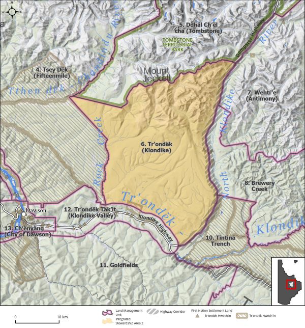
Land Use Designation: |
Integrated Stewardship Area 2 |
||
|
Land Status: |
Non-Settlement Land and Tr’ondëk Hwëch’in Settlement Land TH R-38A, TH S-112B1, TH S-142B1, TH S-176B1, TH S-205B1, TH S-206B1, TH S-24B1, TH S-25B1, TH S-26B1/D, TH S-47B1, TH S-71B1, TH S-72B1, TH S-73B1 |
||
|
Area: |
824 km2 |
Planning Region % |
2.1% |
|
|
||||
|
|
||||
|
Walking on the Land Together (Intent Statement) |
||||
|
The vision for this area is to allow for limited sustainable development while ensuring the high ecological value and socio-cultural use remains intact. Located within the Tintina Trench flyway as well as along the North Klondike River, this area offers important habitat for migratory birds, raptors, furbearers, moose, freshwater fish, and salmon. Industrial interests in this area are limited, except for forestry along the Dempster Highway. The use of this area for forestry pursuits as well as continued traditional economic activities, trapping and harvesting, should be maintained. |
||||
|
Tr’ëhudè (Our Way of Life) & Stewardship |
||||
|
There is a long history of Tr’ondëk Hwëch’in connections to this area. It is an area filled with history and a place of cultural continuity for Tr’ondëk Hwëch’in. There is a valley in this LMU where you can see the caribou coming down. People say that it would have been a natural place for ancestors to have camps. Arrowheads have been found in this area. DRPC Commission Members |
||||
|
Special Management Directions (Recommendations to achieve Vision) |
||||
|
In addition to all applicable General Management Directions, this area is subject to: 1. Activities that have the potential to disturb salmon spawning habitat should be suspended during the spawning season (July 1 to August 15). 2. Area is considered to contain critically important habitat for regional lynx populations. Development in this area should ensure impacts to lynx and their key habitat requirements are minimized or avoided. 3. Activities that have the potential to disturb migratory bird nesting should proceed as guided by the Migratory Birds Convention Act and its regulations to minimize and/or avoid impacts to migratory birds. 4. Area represents important headwaters for drinking water catchment for City of Dawson and surrounding residential neighbourhoods. Development in this area should not impact this important water source (see Section 5.3.5.1 – Community Water, page 118). 5. The North Fork Hydro site as identified in the THFA should be considered at the discretion of both Parties. 6. Dempster Highway Corridor sub-regional plan will affect this LMU and thus interim measures and future sub-regional planning direction should be considered (see Section 5.4.3.1.1 – Dempster Highway Corridor, page 130). |
||||
|
Cumulative Effects Thresholds |
||||
|
Relative to LMU Size* |
Surface Disturbance (%) |
Linear Disturbance (km/km2) |
||
|
Current disturbance (2020) |
0.27 |
0.31 |
||
|
Precautionary |
0.25 |
0.125 |
||
|
Cautionary |
0.75 |
0.375 |
||
|
Critical |
1 |
0.5 |
||
|
On the ground amounts** |
Surface Disturbance (km2) |
Linear Disturbance (km) |
||
|
Current disturbance (2020) |
2.17 |
255 |
||
|
Room under cautionary threshold*** |
3.90 |
48.6 |
||
|
Precautionary |
2.02 |
101 |
||
|
Cautionary |
6.07 |
304 |
||
|
Critical |
8.10 |
405 |
||
|
*These are proportional to the size of the LMU, and correspond to table 3-2 of the Recommended Plan. They are measured in the % of the LMU that can be disturbed (“Surface Disturbance”) and in km/km2 (“Linear Disturbance Density”). **These are amounts that can be measured and apply to the whole LMU and would be more familiar to project proponents and regulators. They are measured in km2 of disturbance and in km of linear disturbance (e.g., roads, trails and cutlines). ***How much more disturbance can be added to existing disturbance before the cautionary threshold is reached. |
||||
Cumulative Effects Indicators
Surface Disturbance
Linear Disturbance
Precautionary |
Cautionary |
Critical |
These gauges show how much of each disturbance indicator there is in the LMU with the needle and the large number near the middle. The colours indicate disturbance level zones or “management thresholds”. If the needle is in the white zone, no threshold has been reached.
More information on our Cumulative Effects Framework is found here.

|
Priority Objectives |
|
|
ü Healthy populations of migratory and non-migratory birds and raptors, including the preservation of flyways and other key habitat. ü Continued and successful traditional land use and traditional economic activities. ü Key use areas, infrastructure, and resources that support traditional economy are preserved. ü Opportunity for sustainable forestry that contributes to a growing diversified economy, local employment, and economic stimulus. |
|
|
Rationale for Designation |
|
|
· Heavy multi-use area with conflicting land uses, and important areas for commercial fuelwood harvesting. · An ISA 2 designation with the special management directions recommended above should allow for continued sustainable growth of the important industrial aspects of this area without undermining ecological and socio-cultural values. |
|
|
Ecological Integrity and Conservation Value |
|
|
Birds |
Presence of raptor nests along North Klondike River and within the Tintina Trench Flyway, important for migratory birds. Contains high concern habitat for migratory birds, and watercourses and ponds offer important habitat for waterfowl, including swans, cranes, ducks, geese, and shorebirds. Presence of key sharp tailed grouse habitat areas and some high elevation habitat (<1,000 m) which is important for some migratory bird species. |
|
Caribou |
Within the range of the Fortymile caribou herd and contains some key winter habitat and spring/fall migration corridor areas. |
|
Ecosystem Representation |
Part of the McQuesten Highlands ecoregion. |
|
Furbearers |
Beaver and muskrat areas, lesser occurrence of wolverine, ermine, and river otter. Considered to be a regionally important lynx refugium, in which when lynx populations in surrounding areas decline, lynx populations in the Klondike valley and surroundings do not. As such this area can be considered a significant seed source for regional lynx habitats. |
|
Grizzly Bear |
|
|
Landscape Connectivity |
|
|
Moose |
Considered extensive good moose habitat and contains key wildlife area for moose mostly for late winter (February to April) range for calving. |
|
Salmon and other Fish |
The Klondike River watershed offers critical habitat requirements for chinook salmon (spawning, rearing) and important habitat for resident fish species including Arctic grayling. |
|
Sheep |
|
|
Species at Risk |
|
|
Vegetation and Unique Features |
Considered to contain important mineral licks for wildlife. |
|
Water |
Klondike River watershed offers important aquatic habitat values for key wildlife in the Region as well an important drinking water source for residents of the Region. |
|
Wetlands |
Presence of some wetland habitat, including bog, fen, and swamp. |
|
Culture, Heritage Resources and Community Value |
|
|
Community Value |
Given proximity to Dawson and adjacency to main highways, there is potential for recreational pursuits in area, however access into the area remains relatively absent. There are several hiking opportunities along the Yukon Ditch and within Tombstone Mountains south of the park. Snowmobiling occurs along existing trails. |
|
Heritage Resources and Sites |
Occurrence of traditional trails and archaeological sites. Area contains a portion of the Yukon Ditch and associated sites. |
|
Traditional Economy / Traditional Uses |
Important areas for connecting to the land through the practice of land use/economic activities, including trapping, gathering, and harvesting. High cultural value and contemporary use for traditional economic activities. |
|
Socio-economic Value |
|
|
Agriculture |
|
|
Energy |
Presence of historical infrastructure and location of future potential use for hydroelectricity (North Fork Hydro-electric proposal) – see also LMU 10: Tintina Trench (page 212), and Section 5.2.6 – Climate Change (page 102). |
|
Forestry |
High commercial forestry harvesting value. This LMU overlaps the FRMP ‘Klondike River’ Landscape Unit which is high priority planning short-term. Two active THPs: Dempster Highway and Five Mile Dempster Highway. |
|
Mineral Resources |
High to moderate mineral potential in area, some isolated placer leases, and claims, but area is generally low interest for mineral exploration and development. Presence of a past mine site at colliery for coal. |
|
Outfitting and Trapping |
Presence of active trapping and outfitting concession and associated infrastructure. |
|
Tourism |
Limited hiking opportunities, air access only. Located directly adjacent to Tombstone Territorial Park. Potential for Indigenous tourism and interpretation along the Dempster Highway (i.e., Wolf Creek). Opportunities for wildlife viewing and scenic views along highway. |
|
Transportation and Access |
Low accessibility, but adjacent to both the North Klondike Highway and Dempster Highway. |