|
Land Use Designation: |
Special Management Area |
||
|
Land Status: |
Non-Settlement Land |
||
|
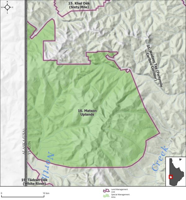
Area: |
708 km2 |
Planning Region % |
1.8% |
|
|
||||
|
|
||||
|
Walking on the Land Together (Intent Statement) |
||||
|
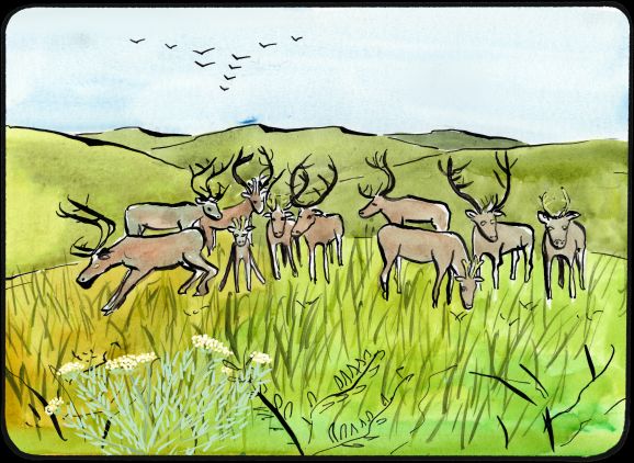
The intent for this area is the preservation of core summer habitat required for the continued growth and survival of the Fortymile Caribou Herd within its Yukon range. The Fortymile Caribou Herd is of significant cultural importance to Tr’ondëk Hwëch’in and offers important opportunities for subsistence harvesting and stewardship. While much of the herd’s Yukon range overlaps with land use disturbance, parts of the Matson Uplands remain relatively undeveloped. It is important that habitat requirements for the herd be prioritized in this area. |
||||
|
Tr’ëhudè (Our Way of Life) & Stewardship |
||||
|
Caribou have provided food, traditional supplies/tools, and clothing for the Tr’ondëk Hwëch’in people for thousands of years, and it is critical that this connection remain for future generations. As stewards of this land, it is crucial that the Tr’ondëk Hwëch’in protect caribou and their habitat as it is a part of cultural continuity and a way of life. Tr’ondëk Hwëch’in did not harvest the Fortymile Caribou herd for decades due to the depletion of the herd. In recent years the herd has rebounded to some extent and the Tr’ondëk Hwëch’in have recently started to rebuild a cultural connection through subsistence harvesting activities. (Adapted from Tr’ondëk Hwëch’in Review of the Dawson Regional Draft Plan, 2021) |
||||
|
Special Management Directions (Recommendations to achieve Vision) |
||||
|
In addition to all applicable General Management Directions, this area is subject to: 1. Withdrawal of all lands from placer and quartz mineral staking. 2. Access: a. No new surface access. b. Continued use of existing access. 3. No new industrial land uses. |
||||
|
Cumulative Effects Thresholds |
||||
|
Relative to LMU Size* |
Surface Disturbance (%) |
Linear Disturbance (km/km2) |
||
|
Current disturbance (2020) |
0.01 |
0.29 |
||
|
Precautionary |
N/A |
N/A |
||
|
Cautionary |
N/A |
N/A |
||
|
Critical |
N/A |
N/A |
||
|
On the ground amounts** |
Surface Disturbance (km2) |
Linear Disturbance (km) |
||
|
Current disturbance (2020) |
0.09 |
202 |
||
|
Room under cautionary threshold*** |
no new surface disturbance |
no new linear disturbance |
||
|
Precautionary |
N/A |
N/A |
||
|
Cautionary |
N/A |
N/A |
||
|
Critical |
N/A |
N/A |
||
|
*These are proportional to the size of the LMU, and correspond to table 3-2 of the Recommended Plan. They are measured in the % of the LMU that can be disturbed (“Surface Disturbance”) and in km/km2 (“Linear Disturbance Density”). **These are amounts that can be measured and apply to the whole LMU and would be more familiar to project proponents and regulators. They are measured in km2 of disturbance and in km of linear disturbance (e.g., roads, trails and cutlines). ***How much more disturbance can be added to existing disturbance before the cautionary threshold is reached. |
||||
Cumulative Effects Indicators
Surface Disturbance
Linear Disturbance
Precautionary |
Cautionary |
Critical |
These gauges show how much of each disturbance indicator there is in the LMU with the needle and the large number near the middle. The colours indicate disturbance level zones or “management thresholds”. If the needle is in the white zone, no threshold has been reached.
More information on our Cumulative Effects Framework is found here.

|
Priority Objectives |
|
ü Protection of traditional land use/economic activities and harvesting. ü Healthy and resilient caribou herd populations that grow towards historic levels. ü Habitat and migration pathways are sufficient to support historic population levels. ü First Nation constitutionally protected rights for harvesting and subsistence activities as obligated in the FNFA are upheld. |
|
Rationale for Designation |
|
|
· Matson Uplands have been identified as containing critical summer habitat for Fortymile caribou herd, winter range for both Fortymile and Nelchina caribou, and critical migration pathways for the herd during spring, summer, and fall. · The Fortymile Caribou Herd overlaps with areas of high human-caused disturbance, and the herd is at significant risk of experiencing a cumulative impact from further development, particularly of critical summer and migratory ranges. · Major issues facing the herd are barriers to movement and loss of habitat. It is important that the remaining critical habitat within this area be preserved, and migratory pathways of this herd not be impeded or bisected at critical pinch points. |
|
|
Ecological Integrity and Conservation Value |
|
|
Birds |
Extensive inclusion of high elevation (>1,000 m) habitat crucial for some migratory bird species. |
|
Caribou |
This area overlaps with two caribou herd ranges—the Fortymile and Nelchina Caribou Herds—and includes migration corridors and winter and summer habitat for caribou. Identified as critical habitat for Fortymile Caribou Herd persistence. |
|
Ecosystem Representation |
Klondike Plateau ecoregion. |
|
Furbearers |
|
|
Grizzly Bear |
|
|
Landscape Connectivity |
Area provides landscapes connectivity from Alaska into Yukon necessary for caribou migration. |
|
Moose |
|
|
Salmon and other Fish |
|
|
Sheep |
|
|
Species at Risk |
|
|
Vegetation and Unique Features |
Unglaciated areas > 1,300 m in elevation, presence of rare endemic plant species. |
|
Water |
Extensive inclusion of high elevation (>1,000 m) habitat crucial for some migratory bird species. |
|
Wetlands |
This area overlaps with two caribou herd ranges—the Fortymile and Nelchina Caribou Herds—and includes migration corridors and winter and summer habitat for caribou. Identified as critical habitat for Fortymile Caribou Herd persistence. |
|
Culture, Heritage Resources and Community Value |
|
|
Community Value |
Some recreation activities on trails. |
|
Heritage Resources and Sites |
|
|
Traditional Economy / Traditional Uses |
Traditional use area important for trapping; high ecological importance for moose and caribou habitats that support subsistence harvest. Ongoing efforts by Tr’ondëk Hwëch’in to reconnect with the Fortymile herd through community hunts and educational camps. |
|
Socio-economic Value |
|
|
Agriculture |
|
|
Energy |
|
|
Forestry |
Overlaps with the Sixty Mile River Central Landscape Unit of the Dawson Forest Resources Management Plan. Unit is designated for medium priority for short-term forest resource development; however, the area is high elevation and limited in forest resource potential. |
|
Mineral Resources |
No active quartz claims or permits in this area but the area has high to medium mineral potential (see Map 8 – Non-Renewable Economic Development: Potential and Interests). |
|
Outfitting and Trapping |
Area overlaps with trapping concession. |
|
Tourism |
|
|
Transportation and Access |
Existing all-season access and some secondary access trails into the area, as well as air access (landing strips). |