|
Land Use Designation: |
Sub-regional Planning Area |
||
|
Land Status: |
Non-Settlement Land and Settlement Land, including 52 Tr’ondëk Hwëch’in Settlement Land Parcels |
||
|
Area: |
926 km2 |
Planning Region % |
2.3% |
 |
 |
 |
|
Walking on the Land Together (Intent Statement) |
|
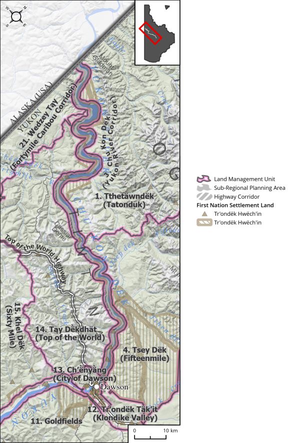
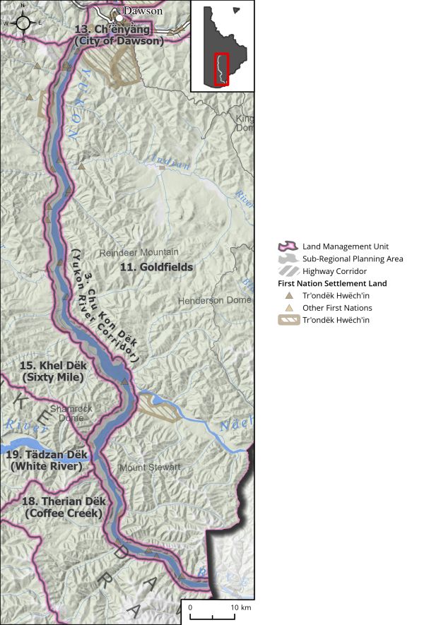
The vision for this area is for future planning that will focus on protecting and enhancing water quality and salmon habitat; protecting the scenic values that attract tourism opportunities; preserving important cultural sites; and managing important industrial access points. The Yukon River Corridor represents a significant multi-use area and transportation corridor for the Dawson Region. The significance of this area is demonstrated by the abundance of identified heritage and cultural sites along this historic route, and it continues to be an area of immense cultural value to Tr’ondëk Hwëch’in. The corridor provides rich habitat for key species in the region including salmon, moose, raptors, and species at risk, and it is important for facilitating a diverse range of economic development activities including mining, tourism, agriculture, and recreation. Different pressures and land uses exist to the north and south of the corridor. Although the scope of the Dawson Regional Plan is bound by the extent of the planning region, the Yukon River is a single ecological feature and should ultimately be managed as such. The long-term vision for the future of the Yukon River is to encourage the management of the river in its entirety to honour its many functions, and its importance to the people of the Yukon. This Plan proposes sub-regional planning be completed for this LMU under Chapter 11 of the THFA and for interim measures to be in place until sub-regional planning is completed. |
|
Tr’ëhudè (Our Way of Life) & Stewardship |
|
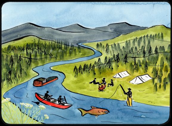
“Throughout the stories…you will hear of Smart Man, Beaver Man, and Tsà’ Wëzhè. This is the Traveller, known by many names up and down the Yukon River and across the north. Tsà’ Wëzhè went into the world and made it safe for us, the Dënezhu. He made agreements with the land and animals that ensured our survival: the land and animals would provide for us for as long as we lived by those agreements, for as long as we lived Tr’ëhudè. The stories of Tsà’ Wëzhè, Beaver Man, Smart Man, the Traveller, teach us that Tr’ëhudè means to live in integrity, justice/balance, interdependence, and respect, and we must adhere to these values if we want the land, our culture, and our community, to survive.” There are many places along the Yukon River Corridor where the interrelationship between cultural education and connection to the land take place. This is a value that is held strongly by Tr’ondëk Hwëch’in and it is important that these spaces are protected to ensure these opportunities can be preserved for the youth. The River is central to the Tr’ondëk Hwëch’in cultural landscape. |
|
Special Management Directions (Recommendations to achieve Vision) |
|
In addition to all applicable General Management Directions, this area is subject to: A phased approach to management of LMU 3: Chu Kon Dëk (Yukon River Corridor): 1. Interim measures – applied upon Plan approval until sub-regional plan approved 1. Withdrawal of lands from placer and quartz mineral staking until the completion and approval of a sub-regional plan or such a time as both Parties agree to remove withdrawal. 2. When a claim expires it should be withdrawn from further staking while interim withdrawal is in place. 3. Mineral development permitted within existing mineral tenure. 4. Industrial land use permitted within ISA 2 cumulative effects thresholds. 5. A scoping exercise for Yukon River sub-regional planning issues and interests to include a DRPC hosted Yukon River Summit/gathering with affected First Nations, community, and stakeholders. 6. A buffer near the Forty Mile Heritage Site should be implemented to protect the cultural significance and multi-use nature of the site. 2. Sub-Regional Planning 1. To be conducted by the DRPC and initiated within 6 months of Dawson Regional Land Use Plan approval. 2. Consideration should be given to the differences in activities and activity levels to the north and to the south of the City of Dawson for the management of the corridor. 3. Sub-Regional planning should specifically plan for the management of activities along the Yukon River Corridor within the Dawson Planning Region. 4. Recreation management, and access management (roads, barges, etc.) should be key focus areas of sub-regional planning. 5. Maintaining wilderness characteristics of river for valued recreational, traditional, and economic (tourism) purposes should be considered. 6. A buffer near the Forty Mile Camp/Heritage Site should be implemented to protect the cultural significance and multi-use nature of the site. 3. Comprehensive Yukon River Management (Future Vision) 1. A Yukon-wide plan for the health and vitality of the Socio-cultural, economic, and environmental values of the entire Yukon River should be developed. 2. Consideration of legal personhood for the Yukon River (precedent exists for Magpie River in Quebec). 3. Explore the possibility of developing a Yukon River Management Plan with all affected First Nations, territorial, and municipal governments to gauge interest in the concept to determine its feasibility. |
|
Cumulative Effects Thresholds |
||
|
Relative to LMU Size* |
Surface Disturbance (%) |
Linear Disturbance (km/km2) |
|
Current disturbance (2020) |
0.11 |
0.22 |
|
Precautionary |
0.25 |
0.125 |
|
Cautionary |
0.75 |
0.375 |
|
Critical |
1 |
0.5 |
|
On the ground amounts** |
Surface Disturbance (km2) |
Linear Disturbance (km) |
|
Current disturbance (2020) |
1.1 |
208 |
|
Room under cautionary threshold*** |
5.9 |
139 |
|
Precautionary |
2.31 |
116 |
|
Cautionary |
6.94 |
347 |
|
Critical |
9.26 |
463 |
|
*These are proportional to the size of the LMU, and correspond to table 3-2 of the Recommended Plan. They are measured in the % of the LMU that can be disturbed (“Surface Disturbance”) and in km/km2 (“Linear Disturbance Density”). **These are amounts that can be measured and apply to the whole LMU and would be more familiar to project proponents and regulators. They are measured in km2 of disturbance and in km of linear disturbance (e.g., roads, trails and cutlines). ***How much more disturbance can be added to existing disturbance before the cautionary threshold is reached. |
||
Cumulative Effects Indicators
Surface Disturbance
Linear Disturbance
Precautionary |
Cautionary |
Critical |
These gauges show how much of each disturbance indicator there is in the LMU with the needle and the large number near the middle. The colours indicate disturbance level zones or “management thresholds”. If the needle is in the white zone, no threshold has been reached.
More information on our Cumulative Effects Framework is found here.

|
Priority Objectives |
|
ü People can access the land, water, and resources in a way that acknowledges and supports the values and minimizes conflicts and cumulative effects. ü Healthy aquatic ecosystems and watersheds. ü Sustainable fish and wildlife populations supported by healthy aquatic and terrestrial habitats. ü Stewardship of rivers to enhance salmon habitat and support salmon recovery. ü Salmon migration routes that allow for salmon recovery. ü Healthy populations of migratory and non-migratory birds and raptors, including the preservation of flyways and other key habitat. ü Tourism activities are carried out in a manner consistent with the principles of stewardship and sustainability. ü Tourism and recreational experiences include scenic viewscapes, wildlife viewing, culture appreciation, and heritage education within appropriate areas of the Planning Region. ü Increased opportunities for tourism experiences that contribute to a growing diversified economy, local employment, and economic stimulus. |
|
Rationale for Designation |
|
● Important multi-purpose area that represents a valuable transportation route, numerous habitat qualities for terrestrial and aquatic species, and immense cultural value to the Tr’ondëk Hwëch’in. ● Represents high, year-round recreational, industrial, historical, trapping, and educational value and provides opportunities for angling and wildlife viewing as well as the aesthetic qualities of a northern wilderness river. ● Provides for salmon habitat for adults and juveniles, tributaries to the river also offer important spawning habitat. ● Opportunities for land-based learning and cultural education opportunities for Tr’ondëk Hwëch’in youth are located along the river. ● Numerous Tr’ondëk Hwëch’in Settlement Lands exist along the river. |
|
Ecological Integrity and Conservation Value |
|
|
Birds |
High value waterbird habitat along riparian areas, and raptor key areas have been identified along the Yukon River. |
|
Caribou |
This area overlaps with two caribou herd ranges: the Fortymile and Nelchina caribou herds and includes migration corridors and winter habitat for the Fortymile caribou. |
|
Ecosystem Representation |
Part of Boreal Cordillera ecozone, Klondike Plateau ecoregion. |
|
Furbearers |
Important salmon habitat/migratory corridor as well as home to several resident fish species. |
|
Grizzly Bear |
|
|
Landscape Connectivity |
|
|
Moose |
Extensive area considered good habitat for moose. |
|
Salmon and other Fish |
Important habitat for salmon migration/spawning and freshwater fish. |
|
Sheep |
|
|
Species at Risk |
Presence of Yukon Podistera (SARA Special Concern), Peregrine Falcon (SARA Special Concern), and known Spiked Saxifrage populations. |
|
Vegetation and Unique Features |
Occurrence of known mineral licks within Corridor and rare plant species. |
|
Water |
The Yukon River and its tributaries are a major hydrological feature in the Region and the Territory. |
|
Wetlands |
Wetland and riparian habitat along major watercourse. |
|
Culture, Heritage Resources and Community Value |
|
|
Community Value |
Areas of high recreational significance. The river is highly valued and used by the community and visitors year-round: harvest, hiking, paddling, boating, dog sledding, skiing, snowmobile, transportation, access to trapping, etc. Also used for annual events such as Yukon River Quest and Yukon Quest Dog Sledding. |
|
Heritage Resources and Sites |
Location of traditional routes, historic sites, Tr’ondëk Hwëch’in land use sites, heritage reserves, historic resources, and archaeological sites. |
|
Traditional Economy / Traditional Uses |
Important area for harvesting, gathering, trapping, fishing, and travel that facilitates other land use within this important river corridor. |
|
Socio-economic Value |
|
|
Agriculture |
Yukon River Corridor may offer suitable land for agricultural purposes. |
|
Energy |
|
|
Forestry |
To continue as guided by forest management plans. |
|
Mineral Resources |
Claims along mainstem and along several tributaries near or within the corridor. Infrastructure for mineral development, such as barge landings, trail heads, docks, along mainstem. |
|
Outfitting and Trapping |
Areas overlap with trapping concessions. |
|
Tourism |
Various landing sites and docks provide water access and there are connecting trails off some areas of the mainstem. River traffic consists of barging and recreational boating. River crossing to access communities. |
|
Transportation and Access |
Yukon River Corridor offers ample opportunities for wilderness tourism including canoeing, fishing, hiking, and camping, dog sledding, snowmobile tours, boat tours, wildlife viewing, and increased indigenous tourism opportunities. Hosts many annual events that attract tourists to the area. |
|
Other |
Thriving subsistence and commercial salmon fishery once existed on the river. |