|
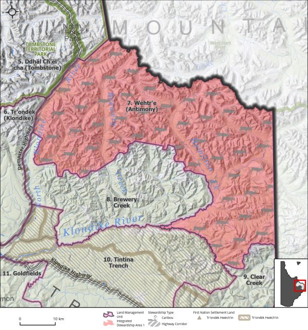
Land Use Designation: |
Integrated Stewardship Area 1 |
||
|
Land Status: |
Non-Settlement Land and Tr’ondëk Hwëch’in Settlement Land TH R-41B, TH S-123B1, TH S-143B1, TH S-144B1, TH S-88B1 |
||
|
Area: |
2144 km2 |
Planning Region % |
5.4% |
|
|
||||
|
|
||||
|
Walking on the Land Together (Intent Statement) |
||||
|
The vision for this area is to protect key wildlife habitat and aesthetic attributes along the Dempster Highway while allowing for limited mineral development within existing tenure and carefully managed surface access. This area has a high conservation focus due to the important habitat of the Hart River and Clear Creek Caribou Herds. This area contains important wildlife habitat for species at risk, including calving, summer and rut habitat for northern mountain woodland caribou and high elevation areas for migratory birds. This area is also located adjacent to two protected areas (Tombstone Territorial Park and the West Hart River Wilderness Area), and thus offers important opportunities for landscape connectivity. The future of this area looks much the same as it is today, recognizing that some mineral development and forestry may still occur. Any development should be accompanied by management and reclamation standards that protect key caribou habitat. |
||||
|
Tr’ëhudè (Our Way of Life) & Stewardship |
||||
|
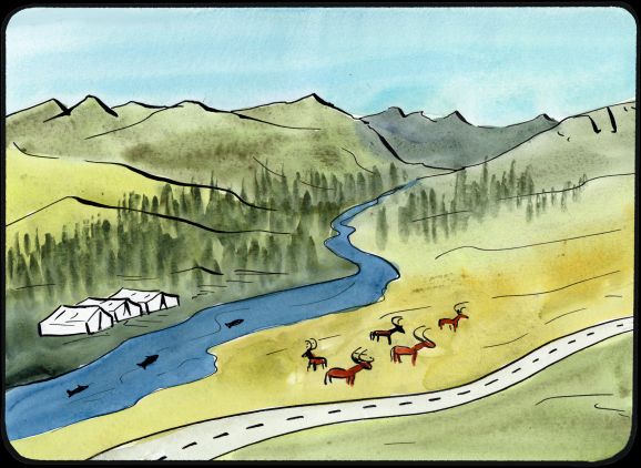
This is an important area for connecting to the land and taking part in Traditional Economic activities including trapping, fishing, gathering, and hunting. There is a Tr’ondëk Hwëch’in camp near here where there is concern about the quality of drinking water from past mining activities. This concern has affected people who use the camp as many will not drink from the creek. |
||||
|
Special Management Directions (Recommendations to achieve Vision) |
||||
|
In addition to all applicable General Management Directions, this area is subject to: 1. Caribou Stewardship overlay area (see Section 3.2.4.1 – Caribou Stewardship Area, page 44). 2. Industrial Land Use: a. Mineral development is permitted within existing mineral tenure. b. Industrial land use is permitted within ISA 1 cumulative effects thresholds. 3. Interim withdrawal of all other lands from placer and quartz mineral staking to be in place until the Access Management plan is completed or Regional Plan 10-year Review or until such a time that both Parties agree to remove. 4. An access management plan / agreement to be jointly created by the Parties which should consider the following: a. New all season surface access: When new access is required, coordinated access routes for industrial activities should be encouraged to reduce linear footprint. b. The viewscape from the Dempster Highway should be maintained. c. The sensitivity of caribou to cumulative effects. d. See also Section 5.4.3.2.2 – Access Management Planning Recommendations (page 140) and Recommended Action 102 for additional guidance on Access Management Plans. e. In the absence of an access management plan, Parties should jointly determine whether new surface access be permitted, with consideration of the above. 5. Dempster Highway Corridor sub-regional plan will affect this LMU and thus interim measures and future sub-regional planning direction should be considered (see Section 5.4.3.1.1 – Dempster Highway Corridor (page 130). |
||||
|
Cumulative Effects Thresholds |
||||
|
Relative to LMU Size* |
Surface Disturbance (%) |
Linear Disturbance (km/km2) |
||
|
Current disturbance (2020) |
0.00 |
0.02 |
||
|
Precautionary |
0.0625 |
0.0625 |
||
|
Cautionary |
0.1875 |
0.1875 |
||
|
Critical |
0.25 |
0.25 |
||
|
On the ground amounts** |
Surface Disturbance (km2) |
Linear Disturbance (km) |
||
|
Current disturbance (2020) |
0.06 |
51 |
||
|
Room under cautionary threshold*** |
4.96 |
352 |
||
|
Precautionary |
1.34 |
134 |
||
|
Cautionary |
4.03 |
403 |
||
|
Critical |
5.37 |
537 |
||
|
*These are proportional to the size of the LMU, and correspond to table 3-2 of the Recommended Plan. They are measured in the % of the LMU that can be disturbed (“Surface Disturbance”) and in km/km2 (“Linear Disturbance Density”). **These are amounts that can be measured and apply to the whole LMU and would be more familiar to project proponents and regulators. They are measured in km2 of disturbance and in km of linear disturbance (e.g., roads, trails and cutlines). ***How much more disturbance can be added to existing disturbance before the cautionary threshold is reached. |
||||
Cumulative Effects Indicators
Surface Disturbance
Linear Disturbance
Precautionary |
Cautionary |
Critical |
These gauges show how much of each disturbance indicator there is in the LMU with the needle and the large number near the middle. The colours indicate disturbance level zones or “management thresholds”. If the needle is in the white zone, no threshold has been reached.
More information on our Cumulative Effects Framework is found here.

|
Priority Objectives |
|
|
ü Maintain connectivity between areas of key wildlife habitat, while considering climate driven shifts in habitat. (Plan Goal) ü Healthy and resilient caribou herd populations that grow towards historic levels. ü Habitat and migration pathways are sufficient to support historic population levels. ü A society that respects and is connected to caribou. ü Sustainable fish and wildlife populations supported by healthy aquatic and terrestrial habitats. ü People can access the land, water, and resources in a way that acknowledges and supports the values in each LMU and minimizes conflicts and cumulative effects. ü Preservation of critical, rare, or unique ecosystems throughout the Planning Region, while considering that some ecosystems are likely to shift due to climate change. ü Tourism and recreational experiences include scenic viewscapes, wildlife viewing, culture appreciation, and heritage education within appropriate areas of the Planning Region. |
|
|
Rationale for Designation |
|
|
· Area contains important calving, post-calving, summer, and rut habitat for the Clear Creek and Hart River Caribou Herds, which are included under the Northern Mountain population of woodland caribou that has been designated a species of Special Concern under SARA. Caribou are a species of considerable cultural, ecological, and economic importance in Yukon. · Area is located entirely within McQuesten Highlands ecoregion, an ecoregion currently absent within Yukon’s protected areas. · Establishing a conservation area will preserve landscape connectivity between West Hart River Wilderness Area of the Peel River Watershed and the Tombstone Territorial Park. · Entirety of upland areas are high elevation (>1,000 m), which provides crucial habitat for migratory bird specialist species. · Area contains existing mineral dispositions for exploration, including critical mineral occurrences. · The viewscape from the Dempster Highway should be maintained for its aesthetic, economic (tourism), and intrinsic value. |
|
|
Ecological Integrity and Conservation Value |
|
|
Birds |
Extensive inclusion of high elevation (>1,000 m) habitat crucial for some migratory bird species. |
|
Caribou |
Overlap with Fortymile, Clear Creek, and Hart River Caribou Herd ranges. Contains key calving, post-calving and summer and winter habitat for mountain caribou, including habitat for calving, post-calving, summer, and rutting. |
|
Ecosystem Representation |
Located within McQuesten Highlands ecoregion which is not represented in Yukon’s protected areas system. |
|
Furbearers |
|
|
Grizzly Bear |
|
|
Landscape Connectivity |
Includes intact areas adjacent to West Hart River Wilderness Area in Peel River Watershed and Tombstone Territorial Park and opportunities for connectivity. |
|
Moose |
Extensive good moose habitat, wildlife key areas for moose later winter (February to April) habitat along Hamilton and Brewery Creeks. |
|
Salmon and other Fish |
Important habitat for salmon migration/spawning and freshwater fish. |
|
Sheep |
Extensive Dall’s sheep habitat throughout the area. |
|
Species at Risk |
Hart River caribou are a Northern Mountain Woodland ecotype, which is listed as a species of Special Concern under SARA. |
|
Vegetation and Unique Features |
A few known occurrences of rare plant species. |
|
Water |
The North Klondike River and its tributaries are an important ecological value. |
|
Wetlands |
Some limited wetland habitats within lowlands including bogs, fens, and marshes, which provide for important wildlife habitat and ecosystem services. |
|
Culture, Heritage Resources and Community Value |
|
|
Community Value |
Some limited off-road recreation opportunities for hiking and sightseeing from the Dempster Highway and canoeing on North Klondike River. Valued viewscapes. Licensed hunting opportunities. |
|
Heritage Resources and Sites |
Several archeological sites, and Settlement Lands of heritage and cultural significance. |
|
Traditional Economy / Traditional Uses |
Supports important woodland caribou; maintaining viewscapes and ecological health and connectivity will protect, enhance, and support traditional economic values and endeavours. |
|
Socio-economic Value |
|
|
Agriculture |
|
|
Energy |
|
|
Forestry |
Located within North and South Klondike River Landscape Units of Forest Resource Management Plan. North Klondike River identified as a high conservation focus area, and South Klondike River identified with a forest resource development focus. Specific area of upper Brewery/Hamilton does not overlap with identified leading forestry species. |
|
Mineral Resources |
Area mostly highly prospective and contains active quartz claims, an active Class 1 operation near Antimony Creek, and a placer prospecting lease on a tributary to Brewery Creek. Area identified as having a strong future in placer potential (see Map 8 – Non-Renewable Economic Development: Potential and Interests). Area contains Critical Mineral Occurrences as per Yukon Geological Survey. |
|
Outfitting and Trapping |
Overlap with several trapping concessions and one active outfitting concession. |
|
Tourism |
No identified high use areas for tourism, located directly adjacent to Tombstone Territorial Park and the Dempster Highway, opportunities for scenic views and wildlife viewing. Dempster Highway is an attraction for motorized tourists. |
|
Transportation and Access |
No major roads or trails into the area, some winter access. Adjacent to Dempster highway corridor. |