|
Land Use Designation: |
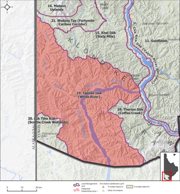
Integrated Stewardship Area 1 |
||
|
Land Status: |
Non-Settlement Land and Tr’ondëk Hwëch’in Settlement Land TH R-44A, TH R-45B, TH R-50A, TH S-17B1 |
||
|
Area: |
4,132 km2 |
Planning Region % |
10.4% |
 |
||||
|
|
||||
|
Walking on the Land Together (Intent Statement) |
||||
|
The intent for this area is to focus on maintaining key values, including wetlands, caribou, sheep, and migratory birds, while allowing for continued sustainable development. This area is relatively undeveloped and inaccessible, having some very localized mineral exploration and development. This area contains abundant intact wetland habitat, which holds strong intrinsic value and provides important ecosystem services to fish and wildlife. |
||||
|
Tr’ëhudè (Our Way of Life) & Stewardship |
||||
|
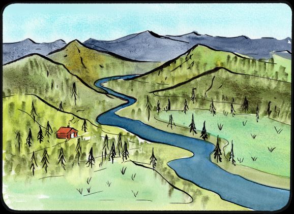
Along this river you can see white ash embedded in the cliffs from a volcano eruption thousands of years ago. The river is also white in colour from silt, if you are silent when you paddle the river, you can hear the silt hitting against the bottom of your canoe. At the confluence of the White and the Yukon rivers, the distinct water from the White flowing into the Yukon is a breathtaking sight. The stories of this river and the events that occurred long ago tell a part of Tr’ondëk Hwëch’in’s history. |
||||
|
Special Management Directions (Recommendations to achieve Vision) |
||||
|
In addition to all applicable General Management Directions, this area is subject to: 1. The Ladue River Wetlands are recommended as a Wetland of Special Importance. 2. Development within undisturbed wetlands is subject to the following: a. No disturbance to field-verified marshes, fens, and bogs. b. Development in all other wetland types subject to general management directions for wetlands (see Section 5.2.5 – Wetlands, page 96). 3. Area contains isolated sheep population. Development in this area should take every precaution to minimize disturbance to sheep and sheep habitat along the White River. 4. The frequency of use and potential impacts from off-road vehicles in this area is not well understood. In line with Section 4 – Cumulative Effects Framework, page 58, if linear feature density thresholds exceed the cautionary level (see Table 3‑2 on page 56 or Appendix 3: Cumulative Effects Framework Thresholds) appropriate avenues should be explored to manage off-road vehicle use. |
||||
|
Cumulative Effects Thresholds |
||||
|
Relative to LMU Size* |
Surface Disturbance (%) |
Linear Disturbance (km/km2) |
||
|
Current disturbance (2020) |
0.03 |
0.09 |
||
|
Precautionary |
0.0625 |
0.0625 |
||
|
Cautionary |
0.1875 |
0.1875 |
||
|
Critical |
0.25 |
0.25 |
||
|
On the ground amounts** |
Surface Disturbance (km2) |
Linear Disturbance (km) |
||
|
Current disturbance (2020) |
1.36 |
391 |
||
|
Room under cautionary threshold*** |
6.39 |
383 |
||
|
Precautionary |
2.58 |
258 |
||
|
Cautionary |
7.75 |
775 |
||
|
Critical |
10.33 |
1033 |
||
|
*These are proportional to the size of the LMU, and correspond to table 3-2 of the Recommended Plan. They are measured in the % of the LMU that can be disturbed (“Surface Disturbance”) and in km/km2 (“Linear Disturbance Density”). **These are amounts that can be measured and apply to the whole LMU and would be more familiar to project proponents and regulators. They are measured in km2 of disturbance and in km of linear disturbance (e.g., roads, trails and cutlines). ***How much more disturbance can be added to existing disturbance before the cautionary threshold is reached. |
||||
Cumulative Effects Indicators
Surface Disturbance
Linear Disturbance
Precautionary |
Cautionary |
Critical |
These gauges show how much of each disturbance indicator there is in the LMU with the needle and the large number near the middle. The colours indicate disturbance level zones or “management thresholds”. If the needle is in the white zone, no threshold has been reached.
More information on our Cumulative Effects Framework is found here.

|
Priority Objectives |
|
|
ü Functioning wetlands ecosystems that support ecological and socio-cultural values. ü Healthy sheep populations are sustained through protection of sheep habitat and limiting disturbance during key times (lambing, over-winter). |
|
|
Rationale for Designation |
|
|
· The Commission wishes to recognize the ecological and socio-cultural value and contributions of wetland habitat to the overall diversity of the Planning Region. · To meet the management intent for this area, a low level of development is allowed under an ISA 1 designation, in combination with the conditions on development in wetland habitat. |
|
|
Ecological Integrity and Conservation Value |
|
|
Birds |
Considered to contain areas of frequent use by migratory birds, including sandhill cranes. Also includes key areas for raptor nesting (golden eagle and peregrine falcon key habitat on White River). Area also contains wetlands that provide important habitat for birds. The North Ladue in particular is known to contain high concern habitat for migratory birds. |
|
Caribou |
Within the range of the Fortymile and Nelchina Caribou Herds and includes key migration routes and winter habitat. |
|
Ecosystem Representation |
Part of the Klondike Plateau ecoregion and the Boreal Cordillera ecozone. Includes remnant rare mammoth steppe ecosystem. |
|
Furbearers |
Key beaver habitat area along the North Ladue river year-round, as well as important stream and pond dwelling habitat. |
|
Grizzly Bear |
|
|
Landscape Connectivity |
Except for North Ladue, the area is mostly absent of any secondary access roads or trails. Some access does exist along North Ladue as part of mineral interests in the area. |
|
Moose |
Extensive good moose habitat and contains key wildlife areas for moose (late winter). |
|
Salmon and other Fish |
Important habitat for salmon migration/spawning and freshwater fish. Movement of adult and juvenile salmon along White River. |
|
Sheep |
Isolated populations at lower elevations along the White River and near the mouth of the White River. |
|
Species at Risk |
|
|
Vegetation and Unique Features |
Presence of known mineral licks. Also includes key areas for raptor nesting (golden eagle and peregrine falcon key habitat on White River). The North Ladue is known to contain high concern habitat for migratory birds. |
|
Water |
A significant wetlands complex is located along the Ladue River. |
|
Wetlands |
Considered to contain areas of frequent use by migratory birds, including sandhill cranes. Area also contains wetlands that provide important habitat for birds. |
|
Culture, Heritage Resources and Community Value |
|
|
Community Value |
Recreational boating opportunities up White River, but the area remains quite inaccessible for recreational purposes. |
|
Heritage Resources and Sites |
Several archaeological resources and heritage sites, and a traditional trail along White River. The mouth of the White River is a traditional gathering place. |
|
Traditional Economy / Traditional Uses |
This area is important for maintaining Tr’ondëk Hwëch’in way of life and connections to the land. It includes important areas for harvesting and hunting. Ensuring wetland habitat remains intact has been noted as an important stewardship duty for Tr’ondëk Hwëch’in. |
|
Socio-economic Value |
|
|
Agriculture |
|
|
Energy |
|
|
Forestry |
White River Landscape Unit of Dawson Forest Resources Management Plan designated as a hinterland forest zone with a low priority for planning in the long-term. |
|
Mineral Resources |
Predominantly high to significantly prospective. Active placer exploration and mining and quartz exploration tenure within the area. High placer potential in the north, coming off the Matson Uplands area. |
|
Outfitting and Trapping |
Active trapping concessions in the area. |
|
Tourism |
This is not a high visitor use area, but has potential for more wilderness tourism activities, especially due to its remoteness. |
|
Transportation and Access |
|