|
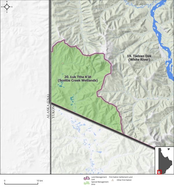
Land Use Designation: |
Special Management Area |
||
|
Land Status: |
Non-Settlement Land and White River First Nation Lands Set Aside S-147B |
||
|
Area: |
356km2 |
Planning Region % |
0.9% |
|
|
||||
|
|
||||
|
Walking on the Land Together (Intent Statement) |
||||
|
Our vision for this area is to protect the function of the wetland complex as fully as possible to respect cultural and ecological values. Protection of this area supports the Commission’s commitment to providing opportunities for connectivity beyond the boundaries of the Region, respecting space for traditional economic activities, and conserving wetlands as important habitat. This area represents the largest intact wetland complex in the Region, and it offers important waterfowl staging grounds and nesting habitat. Access into the area is limited. The area also holds deep intrinsic value for maintaining ecological, social, and cultural connections for Tr’ondëk Hwëch’in and other First Nations with adjacent regions extending into Alaska. The long-term future management of this area will see the eventual end to industrial development with the ultimate goal of fully protecting the wetland complex in its entirety for the ecological and cultural value it holds. |
||||
|
Tr’ëhudè (Our Way of Life) & Stewardship |
||||
|
Wetlands offer numerous socio-cultural values, as expressed by Tr’ondëk Hwëch’in, in inherent value on the landscape, harvesting opportunities, preservation of social connections and cultural vitality, and stewardship. Stewardship is a central tenant of Tr’ondëk Hwëch’in culture. Ensuring wetland habitat remains intact is an important stewardship duty for Tr’ondëk Hwëch’in. Although Scottie Creek is not currently an area of high traditional activity, the preservation of the area for future generations to reconnect with is important to Tr’ondëk Hwëch’in citizens. |
||||
|
Special Management Directions (Recommendations to achieve Vision) |
||||
|
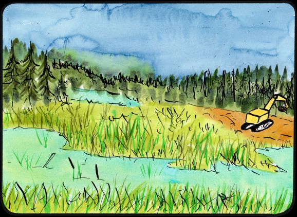
In addition to all applicable General Management Directions, this area is subject to: 1. Industrial land use: a. Mineral development is permitted within existing placer mineral tenure. b. Under the current regulatory system quartz exploration and development is not supported in this LMU (see rationale below). c. Forestry as guided by the Forest Resource Management Plan (subject to wetland general and special management directions). 2. Withdrawal of all other lands from placer and quartz staking. 3. Industrial land use permitted within ISA 2 cumulative effects thresholds. 4. When a mineral claim lapses, the land should revert to the prevailing designation of SMA. 5. Access: a. Continued use of existing winter access road. b. Outside of gaining access to existing dispositions, new surface access is not allowed. 6. Scottie Creek Wetlands are recommended as a Wetland of Special Importance (see Section 5.2.5 – Wetlands, page 96). 7. Development within undisturbed wetlands is subject to the following: a. No disturbance to field verified marshes, fens, and bogs. b. Development in other wetland types subject to general management directions for wetlands. |
||||
|
Cumulative Effects Thresholds |
||||
|
Relative to LMU Size* |
Surface Disturbance (%) |
Linear Disturbance (km/km2) |
||
|
Current disturbance (2020) |
0.32 |
0.4 |
||
|
Precautionary |
0.25 |
0.125 |
||
|
Cautionary |
0.75 |
0.375 |
||
|
Critical |
1 |
0.5 |
||
|
On the ground amounts** |
Surface Disturbance (km2) |
Linear Disturbance (km) |
||
|
Current disturbance (2020) |
1.14 |
144 |
||
|
Room under cautionary threshold*** |
1.53 |
0 |
||
|
Precautionary |
0.89 |
44 |
||
|
Cautionary |
2.67 |
133 |
||
|
Critical |
3.56 |
178 |
||
|
*These are proportional to the size of the LMU, and correspond to table 3-2 of the Recommended Plan. They are measured in the % of the LMU that can be disturbed (“Surface Disturbance”) and in km/km2 (“Linear Disturbance Density”). **These are amounts that can be measured and apply to the whole LMU and would be more familiar to project proponents and regulators. They are measured in km2 of disturbance and in km of linear disturbance (e.g., roads, trails and cutlines). ***How much more disturbance can be added to existing disturbance before the cautionary threshold is reached. |
||||
Cumulative Effects Indicators
Surface Disturbance
Linear Disturbance
Precautionary |
Cautionary |
Critical |
These gauges show how much of each disturbance indicator there is in the LMU with the needle and the large number near the middle. The colours indicate disturbance level zones or “management thresholds”. If the needle is in the white zone, no threshold has been reached.
More information on our Cumulative Effects Framework is found here.

|
Priority Objectives |
|
ü Functioning wetlands ecosystems that support ecological and socio-cultural values. ü Continued and successful traditional land use and traditional economic activities. ü Honour the harvesting and fish and wildlife management customs of First Nations people and provide for ongoing needs for fish and wildlife. ü Sustainable fish and wildlife populations supported by healthy aquatic and terrestrial habitats. ü Honour the harvesting and fish and wildlife management customs of First Nations people and provide for ongoing needs for fish and wildlife (Chapter 16 FNFA). |
|
Rationale for Designation |
|
· Wetlands, as discussed in Section 5.2.5 – Wetlands (page 96), are considered high ecological and socio-cultural value. · Protecting the Scottie Creek wetland complex will protect valuable waterfowl staging and nesting habitat. · Productive placer mines are located in the north portion of LMU · Quartz exploration is not in line with the vision for this LMU due to the ultimate possibility of development into a mine and the downstream impacts on the wetlands complex and water quality. · Deeply important to First Nations who have cultural and heritage ties that are intrinsically linked to the ecological value of the area. · Ecosystem representation of Klondike Plateau for conservation. |
|
Ecological Integrity and Conservation Value |
|
|
Birds |
Important waterfowl staging and nesting habitat. |
|
Caribou |
Located within the winter ranges of the Fortymile and Nelchina Caribou Herds. |
|
Ecosystem Representation |
Ecosystem representation of Klondike Plateau for conservation. |
|
Furbearers |
Scottie Creek Flats is considered a wildlife key area for beaver and muskrat for all functions year round. |
|
Grizzly Bear |
|
|
Landscape Connectivity |
Wetlands are often considered at the wetland complex level given the nature of their interconnectedness and cumulative function. Isolated wetland habitat is less productive. Potential to retain connectivity from this area into adjacent Planning Regions. |
|
Moose |
Within areas considered extensive good moose habitat, moderate moose populations. |
|
Salmon and other Fish |
|
|
Sheep |
|
|
Species at Risk |
Wetland habitat may provide habitat for common species at risk found in the Planning Region. Rare, Species at Risk and endemic plant and mollusk species located within the Scottie Creek Wetlands. |
|
Vegetation and Unique Features |
|
|
Water |
|
|
Wetlands |
Contains extensive undisturbed wetland habitat. |
|
Culture, Heritage Resources and Community Value |
|
|
Community Value |
|
|
Heritage Resources and Sites |
One identified archaeological site in area. |
|
Traditional Economy / Traditional Uses |
Limited access into the area thus limited opportunities for harvesting and gathering, but known and recognized natural resource values including wetland, riparian, and aquatic species. |
|
Socio-economic Value |
|
|
Agriculture |
|
|
Energy |
|
|
Forestry |
Located within the White River Landscape Unit of the Forest Resources Management Plan. Unit identified as a low, long-term priority for planning with a high conservation focus. |
|
Mineral Resources |
Significantly prospective, active placer and quartz claims in the northern portion of the area. |
|
Outfitting and Trapping |
Active trapping concession. |
|
Tourism |
There is currently minimal interest in tourism activities. |
|
Transportation and Access |
Limited access into the area thus limited opportunities for harvesting and gathering. |