|
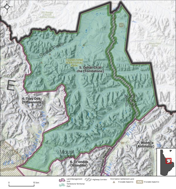
Land Use Designation: |
Special Management Area |
||
|
Land Status: |
Non-Settlement Land and Tr’ondëk Hwëch’in Settlement Land: TH R-19B, TH R-34B, TH S-138B1, TH S-145B1, TH S-28B1, TH S-29B1, TH S-26B1/D, TH S-208B1/D |
||
|
Area: |
2,107 km2 |
Planning Region % |
5.3% |
|
|
||||
|
|
||||
|
Walking on the Land Together (Intent Statement) |
||||
|
The vision for this area is to maintain it as a Special Management Area as per its current designation and as established in the THFA. Tombstone Territorial Park is a protected area established pursuant to Schedule A of Chapter 10 of the THFA and designated as a Natural Environment Park under the Parks and Lands Certainty Act. This regional land use plan will not include planning for the park itself, but it is physically located within the Dawson Planning Region. As indicated in the THFA, in developing a land use plan that includes all or parts of the park, a Regional Land Use Planning Commission shall consider the Tombstone Territorial Park Management Plan (2009). The management plan states: “Tr’ondëk Hwëch’in Settlement Lands are not part of Tombstone Territorial Park and as such are not subject to the Tombstone Territorial Park Management Plan or the Yukon Parks and Land Certainty Act. The Tr’ondëk Hwëch’in may develop legislation under its Self-Government Agreement to regulate activities on its Settlement Land.” Government of Yukon, 2009 Tombstone Territorial Park supports excellent caribou, grizzly and black bear, moose, and sheep populations. These species have been sustainably harvested by subsistence, resident, and non-resident hunters for thousands of years. The location of Tombstone Park is also of significant First Nation cultural history and value, as well as an exceptional attraction for contemporary recreation and tourism. The Tombstone Territorial Park Management Plan Review should carefully consider tourism and increased traffic along the Dempster Highway, and the impacts these activities may have on the values held strongly by Tr’ondëk Hwëch’in and the Dawson community. |
||||
|
Special Management Directions (Recommendations to achieve Vision) |
||||
|
In addition to all applicable General Management Directions, this area is subject to: 1. Existing Plans and Regulations: a. Tombstone Territorial Park Management Plan (2009). b. Dempster Highway Development Area Regulations (C.O.1979/064). 2. Access: a. Tombstone Corridor: Generally, 500m on either side of the centre line of the Dempster Highway, see park management plan for details of corridor (Trondëk Hwëch’in & Government of Yukon, 2009). Managed under the Area Development Act. b. Activities managed within the Corridor may include continued highway maintenance activities, a possible future pipeline, transmission line or other public visitor infrastructure (i.e., fibre optic line). c. Carefully managed surface access should be considered jointly by the Parties to support sustainable tourism activities, forestry, Tr’ondëk Hwëch’in cultural activities, and access to a mineral deposit that has been proven viable by a proponent. 3. Tombstone Territorial Park Management Plan Review. 4. Industrial Land Use: a. Mineral development is permitted within existing mineral tenure. b. Industrial land use permitted within ISA 1 cumulative effects thresholds. 5. Withdrawal of all other lands from placer and quartz mineral staking. 6. See Tombstone Territorial Park Management Plan (2009) for a comprehensive description of the area and values, and allowable activities and management direction. 7. Dempster Highway corridor sub-regional plan will affect this LMU and thus interim measures and future sub-regional planning direction should be considered (see Section 5.4.3.1.1 – Dempster Highway Corridor, page 130). |
||||
|
Cumulative Effects Thresholds |
||||
|
Relative to LMU Size* |
Surface Disturbance (%) |
Linear Disturbance (km/km2) |
||
|
Current disturbance (2020) |
0.0 |
0.05 |
||
|
Precautionary |
0.0625 |
0.0625 |
||
|
Cautionary |
0.1875 |
0.1875 |
||
|
Critical |
0.25 |
0.25 |
||
|
On the ground amounts** |
Surface Disturbance (km2) |
Linear Disturbance (km) |
||
|
Current disturbance (2020) |
0.06 |
112 |
||
|
Room under cautionary threshold*** |
3.8 |
276 |
||
|
Precautionary |
1.29 |
129 |
||
|
Cautionary |
3.88 |
388 |
||
|
Critical |
5.18 |
518 |
||
|
*These are proportional to the size of the LMU, and correspond to table 3-2 of the Recommended Plan. They are measured in the % of the LMU that can be disturbed (“Surface Disturbance”) and in km/km2 (“Linear Disturbance Density”). **These are amounts that can be measured and apply to the whole LMU and would be more familiar to project proponents and regulators. They are measured in km2 of disturbance and in km of linear disturbance (e.g., roads, trails and cutlines). ***How much more disturbance can be added to existing disturbance before the cautionary threshold is reached. |
||||
Cumulative Effects Indicators
Surface Disturbance
Linear Disturbance
Precautionary |
Cautionary |
Critical |
These gauges show how much of each disturbance indicator there is in the LMU with the needle and the large number near the middle. The colours indicate disturbance level zones or “management thresholds”. If the needle is in the white zone, no threshold has been reached.
More information on our Cumulative Effects Framework is found here.
