|
Land Use Designation: |
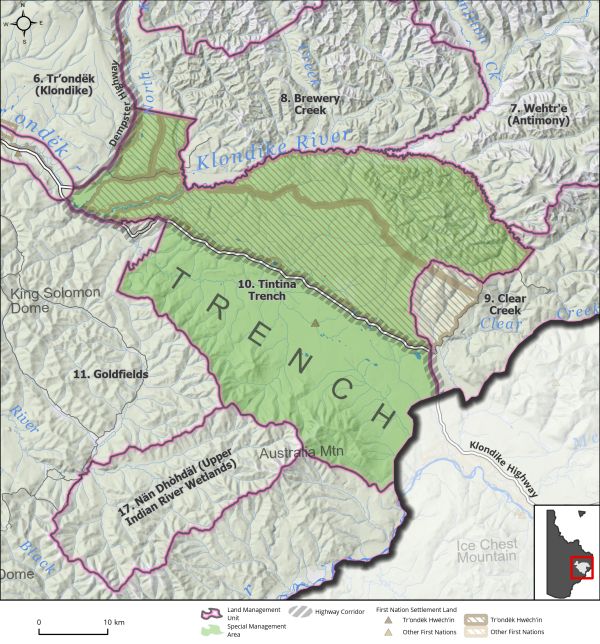
Special Management Area |
||
|
Land Status: |
Non-Settlement Land and Tr’ondëk Hwëch’in Settlement Land TH R-2A, R-7A, R-21B, R-22B, R-79B, R-80B, S-19 B1/D, S-68 B1, S-184 B1 |
||
|
Area: |
1,814 km2 |
Planning Region % |
4.5% |
|
|
||||
|
|
||||
|
Walking on the Land Together (Intent Statement) |
||||
|
The vision for this area is the protection of the important wetland ecological values and to recognize and protect Tr’ondëk Hwëch’in cultural values and traditional use areas. This area contains Tr’ondëk Hwëch’in Settlement Land parcels, including R-22B, also known as Nänkäk Chèhôlay (Land of Plenty), which hosts year-round culture camps for Tr’ondëk Hwëch’in. The area is valued highly by the community of Dawson for recreation, as there is easy access off the Dempster for activities such as hunting, fishing, hiking and camping. The Flat Creek wetlands provide important ecosystem services and are essential to the ecological and socio-cultural value of the Klondike River, an important habitat for spawning salmon and the source of Dawson’s drinking water. There are also areas of high agricultural value. The Tintina Trench Flyway provides valuable habitat for migratory birds. The area is also important to the First Nation of Nacho Nyäk Dun. Future management of this area should ensure First Nations’ traditional use is able to continue unimpeded and to ensure this valuable landscape is protected for future generations. |
||||
|
Tr’ëhudè (Our Way of Life) & Stewardship |
||||
|
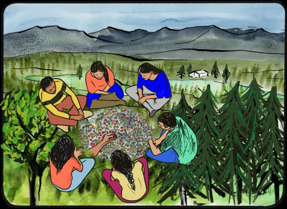
“Nänkäk Chèhôlay (The Land of Plenty) is a place where the land can provide for you and you could live forever, it is a place of healing.” Debbie Nagano, DRPC Chair Residential school survivors chose this place for Tr’ondëk Hwëch’in citizens. It is close to town which makes it an accessible place for citizens to reconnect with the land and with each other. It is a place of importance to Elders where stories can be shared, and people can engage in cultural activities. Continued peaceful use and enjoyment of this area by Tr’ondëk Hwëch’in for traditional activities including harvesting, recreational pursuits and forestry opportunities is a priority. |
||||
|
Special Management Directions (Recommendations to achieve Vision) |
||||
|
In addition to all applicable General Management Directions, this area is subject to: 1. Industrial Use: a. Industrial land use permitted within ISA 2 cumulative effects thresholds. b. Forestry and fuel wood harvest as guided by the Dawson Forest Resources Management Plan. c. Any industrial activity must consider the strong conservation value of this area, take into consideration the objectives, values, and rationale listed in this Plan and would require agreement of both Parties. d. The North Fork Hydro site as identified in the THFA would be considered at the discretion of both Parties. e. Agricultural Corridor Area: Agricultural leases permitted within a 2km buffer on either side of the North Klondike Highway (see Section 3.2.5 – Corridor Areas, page 44) 2. Withdrawal of all lands from placer and quartz mineral staking. 3. In the absence of a SMA management plan, surface access should be managed jointly by the Parties in consideration of sustainable development and cultural activities, including tourism, agriculture, and forestry. 4. Designation is not intended to limit Tr’ondëk Hwëch’in’s ability to access the land and develop infrastructure for traditional land use activities. 5. This area contains important habitat for sharp-tailed grouse, which are a species of immediate management concern. Development in this area should be planned to minimize impacts to key habitat for sharp-tailed grouse. 6. Dempster Corridor sub-regional plan will affect this LMU and thus interim measures and future sub-regional planning direction should be considered (see Section 5.4.3.1.1 – Dempster Highway Corridor, page 130). 7. Wetlands: a. Consideration of Flat Creek Wetlands as a Wetland of Special Importance. b. As per wetland direction in Section 5.2.5 – Wetlands (page 96), no development should occur in bogs, fens, or marshes in an SMA. |
||||
|
Cumulative Effects Thresholds |
||||
|
Relative to LMU Size* |
Surface Disturbance (%) |
Linear Disturbance (km/km2) |
||
|
Current disturbance (2020) |
0.07 |
0.23 |
||
|
Precautionary |
0.25 |
0.125 |
||
|
Cautionary |
0.75 |
0.375 |
||
|
Critical |
1 |
0.5 |
||
|
On the ground amounts** |
Surface Disturbance (km2) |
Linear Disturbance (km) |
||
|
Current disturbance (2020) |
1.26 |
401 |
||
|
Room under cautionary threshold*** |
12.09 |
267 |
||
|
Precautionary |
4.45 |
223 |
||
|
Cautionary |
13.35 |
668 |
||
|
Critical |
17.80 |
890 |
||
|
*These are proportional to the size of the LMU, and correspond to table 3-2 of the Recommended Plan. They are measured in the % of the LMU that can be disturbed (“Surface Disturbance”) and in km/km2 (“Linear Disturbance Density”). **These are amounts that can be measured and apply to the whole LMU and would be more familiar to project proponents and regulators. They are measured in km2 of disturbance and in km of linear disturbance (e.g., roads, trails and cutlines). ***How much more disturbance can be added to existing disturbance before the cautionary threshold is reached. |
||||
Cumulative Effects Indicators
Surface Disturbance
Linear Disturbance
Precautionary |
Cautionary |
Critical |
These gauges show how much of each disturbance indicator there is in the LMU with the needle and the large number near the middle. The colours indicate disturbance level zones or “management thresholds”. If the needle is in the white zone, no threshold has been reached.
More information on our Cumulative Effects Framework is found here.

|
Priority Objectives |
|
|
ü Recognize and protect a way of life that is based on an economic and spiritual relationship between Tr’ondëk Hwëch’in and the land (THFA preamble). ü First Nations citizens are benefitting from the land. ü Continued and successful traditional land use and traditional economic activities. ü Key use areas, infrastructure, and resources that support traditional economy are preserved. ü Healthy populations of migratory and non-migratory birds and raptors, including the preservation of flyways and other key habitat. ü Stewardship of rivers enhance salmon habitat and support salmon recovery. ü Salmon migration routes allow for salmon recovery. ü Functioning wetlands ecosystems support ecological and socio-cultural values. ü Opportunity for sustainable forestry that contributes to a growing diversified economy, local employment, and economic stimulus. |
|
|
Rationale for Designation |
|
|
● R-22 is important for traditional economic activities and is used by Tr’ondëk Hwëch’in both for everyday use t as a host site for year-round culture camps and events. ● The Klondike River (North and South channels) provide important salmon spawning habitat. ● Few mineral claims and minimal surface access. ● The Klondike River is an important drinking water source for the City of Dawson. ● High community recreation value, such as hiking. ● Tintina Trench flyway, an important spring and fall migration pathway for birds, as well as areas of habitat concerns. |
|
|
Ecological Integrity and Conservation Value |
|
|
Birds |
Contains waterfowl staging and breeding areas. Contains a portion of the Tintina Trench Flyway. Contains areas of sharp-tailed grouse key habitat. |
|
Caribou |
Overlaps with the Clear Creek and Fortymile Caribou Herd ranges and contains important summer and winter habitat. |
|
Ecosystem Representation |
Located within McQuesten Highlands ecoregion, which is not represented in Yukon’s protected areas. |
|
Furbearers |
Beaver key habitat (year-round) otter, and lynx. |
|
Grizzly Bear |
Area is accessible and as such, is an area of higher bear-human conflict. |
|
Landscape Connectivity |
Tintina Trench flyway is a migratory bird pathway. |
|
Moose |
Extensive good moose habitat, moderate moose populations. |
|
Salmon and other Fish |
Important habitat for salmon migration/spawning and freshwater fish. Klondike River is a known salmon spawning and grayling habitat. |
|
Sheep |
|
|
Species at Risk |
Sharp-tailed grouse and Clear Creek Caribou Herd. |
|
Vegetation and Unique Features |
Presence of known mineral licks and occurrences of rare plant species. |
|
Water |
Klondike River is an important drinking water and salmon spawning drainage, and contains few small lakes, which are rare in the Region. |
|
Wetlands |
Southern section contains wetlands within lowlands including bogs, fens, and marshes. |
|
Culture, Heritage Resources and Community Value |
|
|
Community Value |
Recreational activities include fishing, hiking, activities on Klondike River, and camping. Presence of some residential properties and land dispositions adjacent to the North Klondike Highway. Seasonal harvesting. It is a place of cross-cultural connection and reconciliation amongst First Nation and non-First Nation people. |
|
Heritage Resources and Sites |
Contains known First Nation land use sites and identified features, as well as archaeological and paleontological sites. Historic sites associated with Yukon Ditch. |
|
Traditional Economy / Traditional Uses |
Land of Plenty (Nänkäk Chèhôlay) hosts year-round cultural activities. Contains known First Nation land use sites and identified features; is an important area for harvesting, fishing, trapping and forestry provisions, along with inter-generational transference of knowledge. |
|
Socio-economic Value |
|
|
Agriculture |
Titled agricultural land in LMU (Flat Creek Hill). |
|
Energy |
North Fork Hydroelectricity potential. |
|
Forestry |
Forestry activities conducted on Settlement Land Blocks as managed by Tr’ondëk Hwëch’in. |
|
Mineral Resources |
Mineral potential in the area is moderate to significantly prospective (Map 8 – Non-Renewable Economic Development: Potential and Interests). |
|
Outfitting and Trapping |
Overlap with one outfitting concession and several trapping concessions with associated infrastructure. |
|
Tourism |
Sightseeing off highway and an active rafting company operates here. |
|
Transportation and Access |
North Klondike Highway runs through this LMU. Secondary road access through Tr’ondëk Hwëch’in Settlement lands and access to the Brewery Creek mining area to the north. |