|
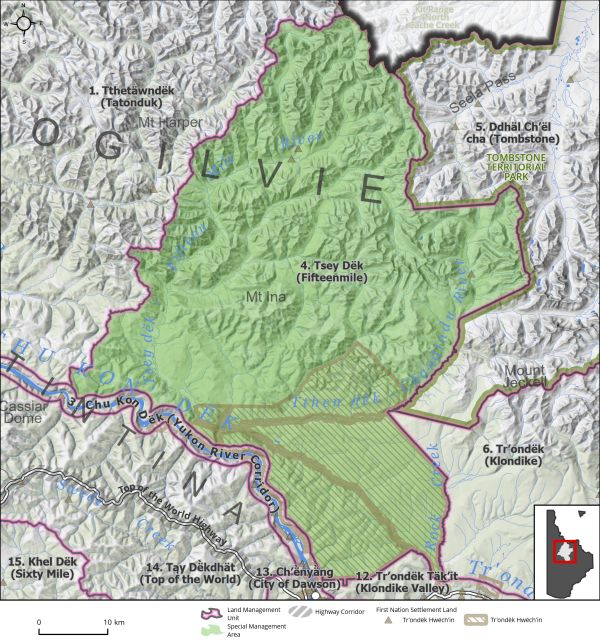
Land Use Designation: |
Special Management Area |
||
|
Land Status: |
Non-Settlement Land and Tr’ondëk Hwëch’in Settlement Land TH R-1A, TH R-3A, TH R-64B, TH R-70B, TH R-83A, TH S-135B1, TH S-136B1, TH S-137B1, TH S-27B1 |
||
|
Area: |
2761 km2 |
Planning Region % |
6.9% |
|
|
|
|
|
Walking on the Land Together (Intent Statement) |
|||||
|
The management intent for this area is to focus on conservation with limited use, and to establish shared management responsibilities between Tr’ondëk Hwëch’in and Government of Yukon. The Tsey Dëk (Fifteenmile) area contains intact ecosystems, and our intent is to ensure landscape connectivity, ecosystem representation, and key areas for wildlife, stewardship, and heritage are protected. This area contains important habitat for the Fortymile, Hart River, and Porcupine Caribou Herds, grizzly bears, and sheep, and is important for trapping and traditional economic activities. The future management for this area sees Tr’ondëk Hwëch’in have the primary role in the management of the SMA in this culturally significant area. Careful management of access and sustainable tourism opportunities should respect the ecological and cultural significance of the area. |
|||||
|
Tr’ëhudè (Our Way of Life) & Stewardship |
|||||
|
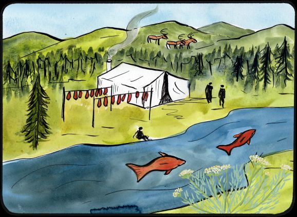
This area is rich in Tr’ondëk Hwëch’in cultural history and contains important traditional routes and trails. Much of this LMU is covered by Settlement Lands which speaks to the importance of this area for maintaining cultural connectivity. The family ties to the land are shared in stories of living memory: “Growing up fishing with drying racks along the beaches along the Chandindu and taking salmon up to Old Crow. We learned not to camp at Fifteenmile because the grizzlies would come down.” John Flynn, DRPC Commission Member |
|||||
|
Special Management Directions (Recommendations to achieve Vision) |
|||||
|
In addition to all applicable General Management Directions, this area is subject to: 1. Tr’ondëk Hwëch’in should have the primary responsibility of managing this area through the establishment of an Indigenous Protected and Conserved Area (IPCA). 2. Industrial Land Use: a. Mineral development is permitted within existing mineral tenure. b. Withdrawal of all other lands from placer and quartz mineral staking. c. Industrial land use permitted within ISA 1 cumulative effects thresholds. 3. In the absence of a SMA management plan, surface access should be considered jointly by the Parties on a project-by-project basis: a. Carefully managed surface access should be considered jointly by the Parties to support sustainable tourism activities, forestry, Tr’ondëk Hwëch’in cultural activities, and access to a mineral deposit that has been proven viable by a proponent. 4. Activities that overlap with sheep habitat (Map 5 – Ungulates) will need to consider impacts to sheep habitat. Impact to late winter habitat and timing windows may apply. 5. The SMA Management plan should consider a long-term sustainable tourism framework. Due to the high concentration of settlement lands this framework should be led by Tr’ondëk Hwëch’in. |
|||||
|
Cumulative Effects Thresholds |
|||||
|
Relative to LMU Size* |
Surface Disturbance (%) |
Linear Disturbance (km/km2) |
|||
|
Current disturbance (2020) |
0.0 |
0.14 |
|||
|
Precautionary |
0.0625 |
0.0625 |
|||
|
Cautionary |
0.1875 |
0.1875 |
|||
|
Critical |
0.25 |
0.25 |
|||
|
On the ground amounts** |
Surface Disturbance (km2) |
Linear Disturbance (km) |
|||
|
Current disturbance (2020) |
0.13 |
376 |
|||
|
Room under cautionary threshold*** |
5.0 |
141 |
|||
|
Precautionary |
1.72 |
172 |
|||
|
Cautionary |
5.17 |
517 |
|||
|
Critical |
6.90 |
690 |
|||
|
*These are proportional to the size of the LMU, and correspond to table 3-2 of the Recommended Plan. They are measured in the % of the LMU that can be disturbed (“Surface Disturbance”) and in km/km2 (“Linear Disturbance Density”). **These are amounts that can be measured and apply to the whole LMU and would be more familiar to project proponents and regulators. They are measured in km2 of disturbance and in km of linear disturbance (e.g., roads, trails and cutlines). ***How much more disturbance can be added to existing disturbance before the cautionary threshold is reached. |
|||||
Cumulative Effects Indicators
Surface Disturbance
Linear Disturbance
Precautionary |
Cautionary |
Critical |
These gauges show how much of each disturbance indicator there is in the LMU with the needle and the large number near the middle. The colours indicate disturbance level zones or “management thresholds”. If the needle is in the white zone, no threshold has been reached.
More information on our Cumulative Effects Framework is found here.

|
Priority Objectives |
|||||
|
ü Recognize and protect a way of life that is based on an economic and spiritual relationship between Tr’ondëk Hwëch’in and the land. (THFA preamble). ü First Nations citizens are benefitting from the land. ü Continued and successful traditional land use and traditional economic activities. ü Key use areas, infrastructure, and resources that support traditional economy are preserved. ü Promote, utilise, and preserve the language and traditions of the Tr’ondëk Hwëch’in (Source: Tr’ondëk Hwëch’in Constitution) and other affected First Nations. ü Historic sites, burials, trails, camps and other heritage resources, including the cultural landscape, are preserved. ü Connectivity between areas of key wildlife habitat, while considering climate driven shifts in habitat. (Plan Goal) ü Stewardship principles are consistently applied by land, water, and resource users. ü Tourism activities are carried out in a manner consistent with the principles of stewardship and sustainability. |
|||||
|
Rationale for Designation |
|||||
|
● An Indigenous focused stewardship approach of this area will enable Tr’ondëk Hwëch’in to exercise their stewardship obligations for this important place. ● Contains traditional routes, sites, as well as areas with high cultural importance and use for Tr’ondëk Hwëch’in, and is critical for cultural continuity, maintaining cultural ties to the land for Tr’ondëk Hwëch’in citizens and providing opportunities to the youth and future generations. ● Active recreation and tourism area including outfitting, hiking, packrafting, snowmobiling, etc. ● Future potential for sustainable tourism economy due to its proximity to Tombstone Park, the City of Dawson, the Yukon Ditch, and its relative accessibility. ● Biodiversity-rich area containing intact ecosystems and species of conservation concern. ● Majority of area located within McQuesten Highlands ecoregion, which is currently absent within Yukon’s protected area system. ● Area overlaps with three caribou herd ranges and extensive habitat for sheep, moose, and grizzly bears, all species of considerable cultural, ecological, and/or economic importance in Yukon. ● Area contains important waterways that provide for salmon habitat. ● Establishing a conservation area will enable landscape connectivity between Kit Range/North Cache Creek in Peel River Watershed and Tombstone Territorial Park. ● Contains some existing mineral dispositions with limited spatial distribution and disturbance. ● Surface access infrastructure is limited. Maintaining this status will ensure the wilderness character of the area remains intact. |
|||||
|
Ecological Integrity and Conservation Value |
|||||
|
Birds |
High value waterbird habitat in riparian areas, key nesting habitat for raptors. Majority of area consists of high elevation (>1,000 m) habitat crucial for migratory bird specialist species. Contains the Tintina Trench Flyway, a major migration corridor and contains stop over sites used by migratory birds during migration. |
||||
|
Caribou |
Fortymile, Porcupine, and Hart River Caribou Herd ranges. Contains critical summer and winter habitat as well as spring/fall and summer corridors for migrating caribou, and important habitat for the Hart River herd. |
||||
|
Ecosystem Representation |
Majority of the area is part of the McQuesten Highlands, which is not currently included within Yukon’s protected areas system. |
||||
|
Furbearers |
|
||||
|
Grizzly Bear |
Contains good habitat for grizzly bears. |
||||
|
Landscape Connectivity |
Adjacent to protected areas Kit Range / North Cache Creek in Peel River Watershed, Tthetäwndëk, and Tombstone Territorial Park. |
||||
|
Moose |
Considered good moose habitat. Wildlife key areas for moose along river corridors (Chandindu, Fifteenmile, and Yukon River north) for late winter (February–April) upland habitat. |
||||
|
Salmon and other Fish |
Important habitat for salmon migration/spawning and freshwater fish. Chandindu and Fifteenmile Rivers provide for chinook salmon spawning habitat. Assumed to be important for all life stages of multiple freshwater fish species. |
||||
|
Sheep |
Large numbers of Dall’s sheep present and extensive sheep habitat throughout the majority of the area (winter range, lambing, and rutting areas). |
||||
|
Species at Risk |
Presence of Yukon Podistera (SARA Special Concern), Peregrine Falcon (SARA Special Concern). |
||||
|
Vegetation and Unique Features |
Contains endemic/rare species, some intact forests (>140 years old), and several known mineral licks. |
||||
|
Water |
Several important undeveloped watercourses and headwaters. |
||||
|
Wetlands |
Available wetland mapping indicates some wetland habitat within area lowlands, including bogs, fens, and marshes, which provide for important wildlife habitat and ecosystem services. |
||||
|
Culture, Heritage Resources and Community Value |
|||||
|
Community Value |
Active year-round recreation opportunities (incl. hiking, snowmobiling, fishing, packrafting, etc.) Southern portion is reasonably accessible for community use and cultural activities. |
||||
|
Heritage Resources and Sites |
Presence of traditional routes along Chandindu, Fifteenmile, and Yukon Rivers. Concentration of archeological sites and a number of historic sites are associated with the Yukon Ditch system. |
||||
|
Traditional Economy / Traditional Uses |
Fall and winter traditional use areas; presence of Tr’ondëk Hwëch’in settlement land parcels in proximity to community (R-3A, R-64B, R-1A, R-70B, R-83A). Important area for family and community connections to the land and ability to exercise Traditional Economic activities. |
||||
|
Socio-economic Value |
|||||
|
Agriculture |
|
||||
|
Energy |
|
||||
|
Forestry |
Overlaps with the Chandindu Landscape Unit of the Dawson Forest Resources Management Plan. Unit is designated as a forest resource management zone with a medium priority for planning and a higher conservation focus. |
||||
|
Mineral Resources |
Minimal upland active quartz claims, majority of area significantly to moderately prospective, some highly prospective areas. Low to moderate probability for placer potential. |
||||
|
Outfitting and Trapping |
Area contains an active outfitting concession and an active trapping concession. |
||||
|
Tourism |
Current and future tourism potential including wilderness tourism, camping, hiking, packrafting, snowmobiling, skiing, close proximity to Tombstone and the City of Dawson, the Yukon Ditch, etc. |
||||
|
Transportation and Access |
Existing overland access routes in the winter/fall. No major access roads or trails into the area. There is some existing access in and around Yukon River, Chandindu, Tombstone Park and the City of Dawson. Access will need to be monitored and managed. |
||||